What to Know
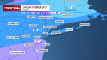
- We're tracking the potential for snow across the tri-state on Friday with most of the area getting 1 to inches, but up to 5 inches for areas in New Jersey and Pennsylvania southwest of the New York City area.
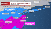
- A winter storm warning will be in effect starting Friday morning for Ocean and western Monmouth counties in New Jersey. New Jersey state offices will be closed Friday.
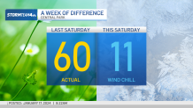
A winter weather advisory will be in place for New York City, Long Island, and areas north and west of the city. New York City has issued a travel advisory for Friday - The coldest air since last February moves in this weekend behind that storm system, and temperatures aren't expected to climb above the freezing mark until Monday
The third winter storm in roughly a week is set to hit the tri-state area Friday, dumping up to 3 inches of snow on most spots before ushering in the coldest air the region has seen in nearly a year. A winter storm warning will be in place for the Jersey Shore while New York City and Long Island will be under a winter weather advisory.
Temperatures are already frigid, barely reaching the freezing mark Thursday, and they'll dip again before the system arrives Friday, meaning this will be an all-snow event for affected areas.
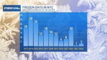
Storm Team 4 is forecasting a widespread 1 to 3 inches of likely for the tri-state area, similar to the recent overnight storm. The latter was enough to break Central Park's 701-day snow drought, but not by much. Areas southwest of New York City in New Jersey and Pennsylvania are likely to see higher totals of 3 to 5 inches.
Get Tri-state area news and weather forecasts to your inbox. Sign up for NBC New York newsletters.
Isolated higher amounts are possible, upwards of 4 inches, with this storm.
A winter weather advisory has been issued starting Friday morning for New York City, Westchester County, Long Island, and areas west of the city. The Jersey Shore and Philadelphia areas will be under a winter storm warning. Check the latest severe weather alerts here.
Local

How much snow will we get?
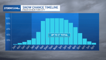
What's the snow timeline? See NYC hourly forecast
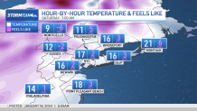
Right now, the snow looks to start falling in the city around sunrise Friday, and taper off between 5 p.m. and 8 p.m. Most spots should see around 3 inches of snowfall over a nine to 12-hour period.
The tail end of the morning commute Friday could be slick, as accumulation begins. It could be more slippery come the evening rush, with any untreated roads, driveways and sidewalks becoming very slick throughout the day.
New York City has issued a travel advisory warning residents to exercise caution when driving, walking, or biking, to allow for extra travel time. Alternate side parking will be suspended on Friday. Recently, the Department of Sanitation reminded property owners about the rules to shovel and clear sidewalks after snowfall.
New Jersey Gov. Phil Murphy announced state offices will be closed tomorrow and urged state employees to work from home. Some school districts have made plans to close or dismiss early on Friday. You can check the full list here.
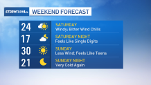
The approaching system will also bring the coldest air since last February behind it. Saturday will be the coldest day, with wind chills in the single digits. Expect more of the same for Sunday.
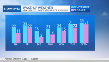
We climb back above freezing by Monday, and then we thaw out for a while. At least we can see a finish line.
Deep freeze
Face-numbing 'feels like' temperatures
Extended weather outlook
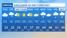
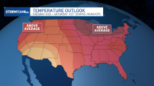
Next week's national picture