What to Know
- Temperatures bump up slightly Thursday to just around the freezing mark as a coastal low develops off the Carolinas.
- We're tracking the potential for more light snow Friday; expect it to be similar to the storm earlier in the week, with a general 1 to 3 inches across the tri-state
- The coldest air since last February moves in this weekend behind that storm system, and temperatures aren't expected to climb above the freezing mark until Monday
The coldest air since last February moves into the tri-state area later this week, on the heels of yet another wintry system that could first lead to accumulating snow for parts of our area.
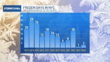
Early estimates indicate a widespread 1 to 3 inches of snow is likely for the tri-state area, similar to the recent overnight storm. The latter was enough to break Central Park's 701-day snow drought, but not by much.

Get Tri-state area news and weather forecasts to your inbox. Sign up for NBC New York newsletters.
Other parts of the tri-state saw higher totals, and schools closed. Delays persisted into Wednesday amid icy roads. Check the latest school closings and delays here.
How much snow will we get?


Local


What's next
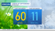
It'll be a stretch of frigid weather -- with temperatures low enough to be dangerous with prolonged exposure.
Temperatures bump up slightly Thursday to just around the freezing mark as a coastal low develops off the Carolinas. At this point, we're expecting light snow accumulation throughout the day Friday, though projections could change.
With surface temperatures so cold, it should be an all-snow event vs. the areas of mixing we had with the last one. Right now, the snow looks to start falling in the city around 9 a.m. or 10 a.m. and taper off between 5 p.m. and 8 p.m. Expect slow-going for the evening rush on the roads come Friday evening, with any untreated roads, driveways and sidewalks becoming very slick throughout the day.
A winter weather advisory has been issued for Friday night for much of New Jersey. That has not been expanded for the city as of now, but it still could if forecast totals increase.
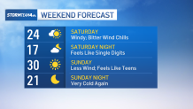
That approaching system will also bring the coldest air since last February behind it. Saturday will be the coldest day, with wind chills in the single digits. Expect more of the same for Sunday.
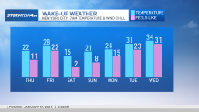
We climb back above freezing by Monday, and then we thaw out for a while. At least we can see a finish line.
Deep freeze
Face-numbing 'feels like' temperatures

Extended weather outlook

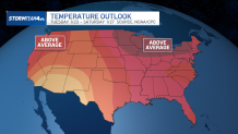
Next week's national picture