An almost unfamiliar sight greeted much of the tri-state Sunday morning when people woke up to find a foot of snow on the ground in parts of the Hudson Valley and northern New Jersey.
The overnight storm system brought the first measurable snowfall in quite some time for the region, although areas like NYC continue to go on a record streak.
By sunrise, the National Weather Service said all winter storm warnings had been canceled and only a winter weather advisory was in effect for the entire interior. Coastal warnings were in effect for morning high tide.
According to the latest snow total reports, Central Park and the rest of the five boroughs had barely recorded more than a trace amount of snow. Up in the Hudson Valley, meanwhile, some New Yorkers were working to shovel out of 12-14 inches. Check for snow totals here.
Get Tri-state area news and weather forecasts to your inbox. Sign up for NBC New York newsletters.
Although several areas saw large accumulations of snow, others primarily got a wintry mix, or straight up rain.
News 4 crews checking out conditions in Orange County found plenty of main roads cleared of snow thanks to the work of around-the-clock snowplow teams. The roads, although plowed of snow, still had plenty of water, making for potentially slick conditions.
Weather Stories
Drivers should exercise caution, especially on side streets, some of which still had snow to be cleared.
Areas closer to NYC, like Westchester, got hit with a mix of snow, sleet and rain. While coastal communities, including Long Island, got rain, rain and more rain. A number of streets experienced low flooding after a long night of showers.
Gov. Kathy Hochul held a briefing in the morning where she highlighted minimal major travel impacts; trains and planes seemed to be running smoothly. Check the latest weather alerts for your neighborhood here.
"Having the snowfall start on a Saturday night and go into Sunday allows us a chance with fewer people on the roads and fewer people who need to get somewhere makes it a lot easier for us," the governor said. "After 16 hours of snowfall, conditions are slushy and wet and the roads are safe and you'll get more details on that, but still be cautious."
The number of power outages across the region also appeared minimal.
Snow showers were expected to continue into Sunday afternoon, but don't expect much more accumulation.
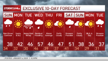
What about the forecast for the rest of this week, and next?
Storm Team 4 is warning of possible ice early Monday for the morning commute and to take it slow on the roads.
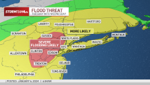
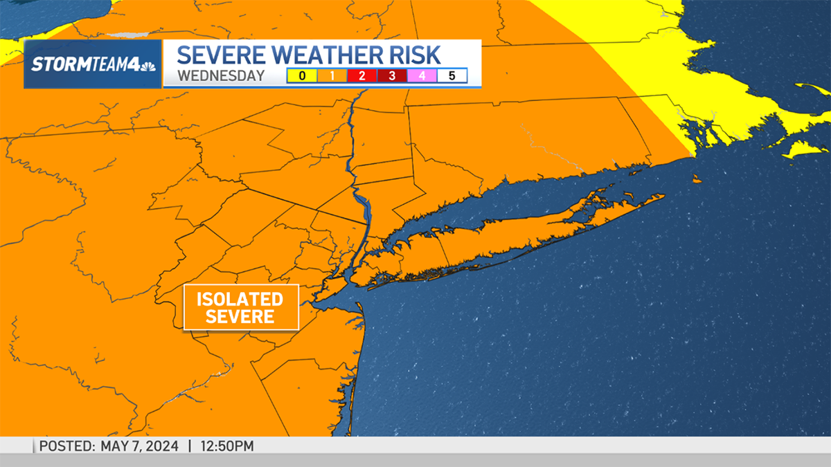
We're tracking another big storm on the heels of this one. The next system looks to hit Tuesday into Wednesday, and with temperatures expected to be relatively warm, that may mean flooding rainfall, on top of any snow that has accumulated and could melt.
Heavy downpours, probably arriving around the Tuesday evening commute and going into the overnight hours, could bring another 2-4 inches of rain.
Areas hit hard by the weekend storm, northern New Jersey and the Hudson Valley especially, will see rain come down on top of already saturated ground, swollen rivers and recent snowpack. It's going to make for a messy combination.
Widespread river flooding will be a threat for many in the tri-state to keep an eye on.