
What to Know
- A powerful winter storm is expected to lay siege to the tri-state area overnight, transitioning from rain to snow in time to make the Tuesday morning commute treacherous
- Snowfall rates up to 2 inches an hour are possible with this system; New York City and much of the tri-state could get up to 8 inches of snow, though much remains uncertain as the storm has been shifting south
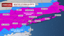
- Most of the area is under a Winter Storm warning until 6 p.m. Tuesday. NYC schools will go fully remote for Tuesday. In addition, NYC has suspended alternate side parking regulations for Tuesday.
An approaching winter storm has the potential to deliver more than half a foot of snow for many across the tri-state Monday night into Tuesday, and projected totals show it could make commuting a nightmare for the New York City area.
Snow totals could reach 8 inches for the city, northern New Jersey, Long Island, the Hudson Valley and nearly all of Connecticut. Areas further north and west of the city could see less, as could central New Jersey and the Jersey Shore, where 3-5 inches are expected.
Isolated spots in areas like Suffolk County on Long Island and New Jersey's Sussex County could see even higher totals.
Get Tri-state area news and weather forecasts to your inbox. Sign up for NBC New York newsletters.
The National Weather Service issued a winter storm warning by Monday afternoon for most of the region, including New York City, Long Island, the Hudson Valley, Fairfield County in Connecticut, and Bergen and Hudson counties in New Jersey. A travel advisory for the city takes effect Tuesday. Check weather alerts here.
New York City schools will go fully remote Tuesday in anticipation of the storm, Mayor Eric Adams announced. Yonkers Public Schools announced they would be closed Tuesday and may consider opening late Wednesday. Check school closings and delays.
"We're strongly encouraging New Yorkers: if you don't have to go out, stay home, and please use public transportation," Adams said Monday. "We want to minimize the number of vehicles on the road so that our apparatus and vehicles can actually deal with the removal of snow and make our movement in the city more feasible."
News
When will it start snowing?
Precipitation will begin late Monday. The storm will bring a period of moderate to heavy snow, and rain transitioning to a rain/snow mix and then snow down the coast.
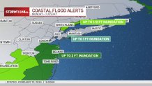
Gusty winds and minor to moderate coastal flooding impacts are possible.
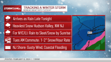
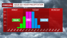
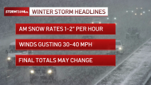
The Tuesday morning commute could be significantly affected by the storm and its impacts. Snowfall rates could hit 1 to 2 inches an hour during the AM rush along the I-95 corridor from Philadelphia to Boston. They could be even higher across eastern Pennsylvania, northern New Jersey and the Hudson Valley.
The snow is expected to taper off before the evening rush, but lingering impacts are likely. The Metropolitan Transit Authority held a news conference regarding its preparations for the snow earlier Monday, saying it will be all systems go, with small changes.
"We are expected to run normal service in buses, subways, LIRR, and on our transit and we will be running a very robust but modified schedule in Metro-North," said MTA Chairman Janno Lieber. The modified service will come with changes to morning and evening peak and branch-line service.
City Sanitation Commissioner Jessica Tisch said they are prepared to plow "every street, every highway and every bike lane as soon as accumulations hit two inches or more” in the five boroughs, with more than 2,000 plows at the ready. More than 700 salt spreading will also start treating roads after midnight.
How much snow will we get?
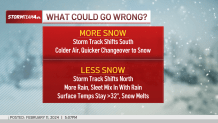
Warmer temperatures, rain and sleet could cut down the snow totals for New York City and coastal areas -- but colder temperatures or a southern shift in track might elevate them.
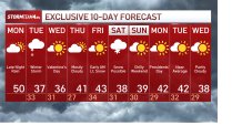
Storm Team 4 is currently forecasting 5 to 8 inches of snow for nearly the entire tri-state area, including New York City, Long Island, the Hudson Valley, northern New Jersey and nearly all of Connecticut. Local snowfall amounts could be higher. Some spots could be snowfall rates up to two inches an hour.
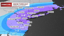
Further south, Philadelphia could get up to 5 inches of snow.
It's important to note that New York City and the nearby coastal areas could see more snow if temperatures trend colder on Tuesday. Coastal flooding, meanwhile, is also a concern with this system.
New York City announced alternate side parking regulations would be suspended for Tuesday. Parking meters will remain in effect -- and the city would like to remind New Yorkers of their responsibilities.
"An important reminder to property owners: while we got the streets, we got the highways and we got the bike lanes, property owners are responsible for clearing snow and ice from the sidewalks," DSNY Commissioner Jessica Tisch said Monday. "We saw in the last two snow events in New York City that the streets were very clear but the sidewalks were pretty treacherous. We don't like to issue summonses and do enforcement, but we are prepared to enforce these very basic safety rules in NYC tomorrow to make sure that our sidewalks are clear and passable."
Westchester County declared a local state of emergency beginning at 10 p.m. on Monday. Residents there are being urged to stock up on food and other supplies so they are not outside once the storm arrives.
Bridgeport declared a snow emergency and parking ban for the Connecticut city beginning at 8 p.m. Monday.
No such emergency was declared for New Jersey as it faces a winter storm warning, but state offices will have a delayed opening, Gov. Phil Murphy said at a press conference. There will also be travel bans in place for commercial vehicles.
"We're expecting the most intense snow to begin tonight, so please if you can, stay off the roads tomorrow morning and work from home. It's a good day for that," Murphy said at a press conference.
Con Edison said it activated 250 mutual aid works to help company crews with any possible service needs. The utility reminded customers they can report an outage at conEd.com/reportoutage or by calling 1-800-752-6633.
All branches of the New York Public Library, the Brooklyn Public Library, and Queens Public Library will be closed on Tuesday.
What can we expect for Valentine's Day?
Once the storm moves through Tuesday, we can expect cool, but seasonable temperatures for the rest of the week.
Valentine's Day is expected to be partly sunny with highs in the 30's and lows in the 20's.
There's a chance of snow showers next Saturday, but it's too early to say anything definitive at this point.
See the latest forecast in your area anytime here.
