
There's another winter storm in the forecast, and this one has the potential to deliver plowable snow for some but not much more than a slushy mix for New York City.
Before the storm arrives late at night, expect Monday to stay dry during the day.
In anticipation of potential snowfall between 5 and 10 inches, the National Weather Service issued a winter storm warning for portions of the tri-state through Tuesday evening. Check weather alerts here.
When will it start snowing?
Get Tri-state area news and weather forecasts to your inbox. Sign up for NBC New York newsletters.
Precipitation will begin Monday late overnight, and start as rain for most of our region. Areas farther north and west of the city, and in the northern half of Connecticut, could see mostly snow.

Tuesday morning as the temperatures get colder, the immediate NYC area will see a changeover to snow.
News


The Tuesday morning commute could be significantly affected by the storm and its impacts. Watch out for any lingering impacts toward the evening commute, but much of the system should be wrapped before then.
How much snow will we get?
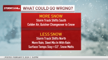
Warmer temperatures, rain and sleet could cut down the snow totals for New York City and coastal areas. Storm Team 4 is currently forecasting under an 1" of snow for New York City, Long Island, Hudson County, and the Jersey Shore.
The Hudson Valley and interior areas of New Jersey, Pennsylvania, and Connecticut are likely to get heavier amounts. High end snow totals could reach 6-10 inches at higher elevations.

It's important to note that New York City and the nearby coastal areas could see more snow if temperatures trend colder on Tuesday.
Storm Team 4 will continue to update the forecast as needed throughout the weekend and as we get closer to the storm.

What can we expect for Valentine's Day?
Once the storm moves through Tuesday, we can expect cool, but seasonable temperatures for the rest of the week.
Valentine's Day is expected to be partly sunny with highs in the 30's and lows in the 20's.
There's a chance of snow showers next Saturday, but it's too early to say anything definitive at this point.

See the latest forecast in your area anytime here.
