We got a hint of April showers on Monday. Then steadier rain moved in Tuesday, bringing periods of heavy, steady rainfall that produced anywhere from half an inch to an inch of precipitation.
But Wednesday will be the wettest and, in some respects, the wildest day of the week. And by wildest, we mean the worst weather.
So keep the umbrellas up and the rainboots on, as more rain is being added to our bucket.
329 medal events. 32 sports. Endless drama. Catch all the action at the Paris Olympics. Sign up for our free Olympics Headlines newsletter.
Flood threat lingers
Weather Stories


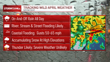
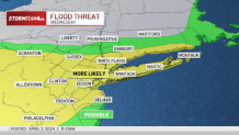
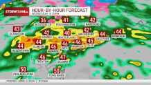
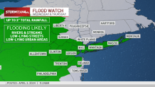
Flooding remains a considerable threat. Waves of heavy rain are expected throughout the day, with some of the heaviest downpours coming in time for the evening commute.
This means ponding for some roadways and closures for others. Keep an eye on low lying areas, especially those near a river or the coast, as those will see the greatest impacts.
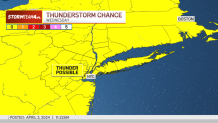
Along with the heavy rain, some thunder is possible, but we are not expecting any severe weather at this time. Those threats will stay to our south.
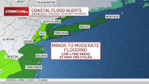
Minor to moderate coastal flooding continues to be a concern during high tides for those along the Jersey Shore, Long Island and Fairfield County.
Winds ratchet up
The biggest change from Tuesday won’t necessarily be seen; it’ll be felt. We’ll be dealing with some very gusty winds. Most will see gusts of 30-40 mph, while those along the coast could see gusts from 50-60 mph.
These wind gusts are strong enough to blow down trees and power lines.
And even when the winds are not gusting, sustained winds will be within the 20-30 mph range, coming from the east-northeast. This will keep the day feeling chilly and raw, with wind chill temperatures staying in the 30s.

Winter weather coming in
Later Wednesday evening, the heavier rain will taper off to scattered showers for most.
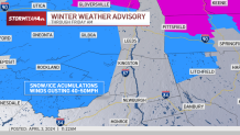
But in our northwestern counties, rain could transition into a wintry mix, with snow and ice accumulations expected, particularly in Sullivan and western Ulster County. Snow showers could linger through the day on Thursday, making travel difficult.
Rain, rain, go away?
Beyond our mess of a Wednesday, Thursday is looking better, but far from perfect. Scattered shower chances remain through the evening and winds, while far less gusty than today, will keep the day feeling chilly and breezy.
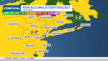
Area-wide, we expect about 2 to 3 inches of rain to fall from this system before it moves on.
Skies clear for Yankee home opener
We are still on track to dry out in time for the Yankees’ home opener Friday afternoon. It’ll be mostly cloudy, cool, and still breezy. If you plan on heading to the Bronx, you’re going to want the extra sweatshirt and make sure your baseball cap is on tight.
Check out the forecast for that and our exclusive 10-day below.