What to Know
- A powerful winter storm triggering weather alerts across the U.S. brought rain Thursday; drenching rains and intense winds, with gusts topping 50 mph possible, will come Friday
- Power outages and coastal flooding are likely with this system; thunder is possible with some of the rain through Friday morning, but no widespread severe weather is expected
- Strong winds are expected to linger through Friday, along with the rain, before temps plunge more than 30 degrees in a matter of hours. Dangerous cold could lead to flash freezes overnight; highs this weekend will stay in the low-to-mid 20s, compounding the ice risk
Thousands of U.S. flights have been canceled and hundreds delayed, as the New York City area battles drenching rains and wild winds from a monstrous winter storm that has jeopardized holiday travel for nearly 200 million Americans.
New York Gov. Kathy Hochul declared a state of emergency Thursday evening as the storm arrived, encouraging people who are looking to travel to do so "before Friday or after Sunday to stay safe."
New Jersey Gov. Phil Murphy closed all state offices for Friday, while both states have issued numerous commercial vehicle restrictions on certain roads, highways, bridges and tunnels due to the strong possibility for high winds and flash freezes.
Get Tri-state area news and weather forecasts to your inbox. Sign up for NBC New York newsletters.
The winter siege began Thursday, and while other parts of the country saw blizzard-like conditions, it didn't feel like much of a winter storm locally. Rain turned heavier overnight, triggering early flash flood warnings for New York's Rockland County. More flooding is expected, especially along the coast and other low-lying and vulnerable areas.
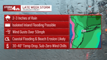
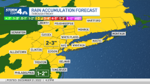
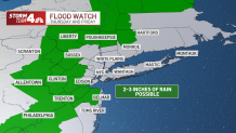
No widespread flash floods are likely, but New York City could see 2 to 3 inches of rainfall by the time the system moves out. The Office of Emergency Management said they are preparing for high winds, heavy rain and freezing temperatures, with a flood warning for southern Queens and flood watches in the other four boroughs.
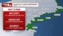
Coastal flood warnings are in effect for the New York City metro area along with Long Island, the Jersey Shore and coastal Connecticut.
Track live weather radar and travel impacts here as the storm hits.
High surf and storm surge could lead to 1 to 3 feet of inundation in the lowest-lying areas during high tide. This could cause road closures and widespread flooding of low-lying areas near waterfronts, but some flooding could extend inland from the waterfronts so stay weather aware. Check the latest weather alerts for your neighborhood here.
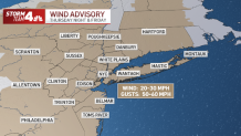
The intense wind gusts will top 50 mph for the I-95 corridor, plenty strong enough to cause damage and could trigger power outages that, given the frigid weather approaching, could be dangerous if they last.
Wind advisories are in place for the entire tri-state area. Sustained winds will be around 20-30 mph.
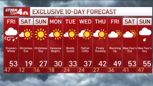
Don't let Friday's early temperatures fool you, either. Yes, it'll climb to the mid-50s by the afternoon, but powerful winds will usher in potentially deadly cold weather, freezing all that rain and creating treacherous conditions for travel.
Another round of rain or snow showers is possible around midday, as temperatures start to plummet.
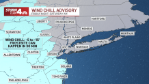
As the dangerous arctic air rushes in, the mercury will plunge by about 30 degrees within a matter of hours. Wind chills will be at or below zero before dark, and temperatures will be in the teens Friday night.
Any wet surfaces, including roadways, could quickly turn to ice by the time many get going early on Christmas Eve, or even the night before. Wind chill warnings will be in effect for much of central and northwestern New Jersey, with the outside air feeling as low as -5 to -15 — which could cause frostbite on exposed skin in as little as 30 minutes.
A National Ripple Effect -- and What's Next
No matter where you're flying, the weather is going to have a domino effect -- so pack your patience. Airlines released alerts in the lead-up to the storm. United had one for the East Coast.
Anyone slated to travel between now and Dec. 25 won't be charged change fees or fare differences for United flights, as long as travel is scheduled in the originally ticketed cabin and the ticket was purchased prior to Dec. 18. The rebooking window is Dec. 22 through Dec. 28.
American Airlines also issued a travel alert, while JetBlue says it'll wave change and cancellation fees for those traveling to or from Chicago, Kansas City, Milwaukee and Minneapolis/St. Paul, given the significant Midwest snow. Southwest Airlines said it canceled 500 of its 4,000 scheduled flights on Thursday and Friday, saying it wanted to maintain safe operations for both passengers and crew.
Alerts may change depending on the weather and airline, so travelers are advised to check with their carriers.
The Christmas weekend will be sunny, but also breezy and bitterly cold, possibly the coldest in decades. Temperatures aren't expected to reach the freezing mark -- even as a high -- until next Tuesday, at the earliest.
The Department of Sanitation will be salting the streets to ward off black ice — and for the first time, the city will salt bike lanes as well. Officials are asking travelers to stay off the roads if at all possible and take mass transit instead.
We should get back above that mark to close out the year, with the long-range forecast predicting highs topping 40 degrees for Dec. 29. It's still too early to know the New Year's Eve forecast for sure, but as of now it looks like it could be a heat wave in comparison, with temps topping 50 degrees. Stay with Storm Team 4 for updates.