
What to Know
- Strong storms could fire up Tuesday and Wednesday after daytime feels-like temps top 100 degrees each day; excessive heat warnings and watches and heat advisories are in effect
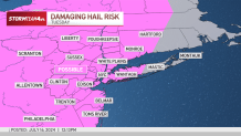
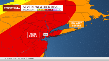
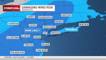
- On Tuesday, the main risks are damaging winds and hail up to an inch in diameter. At this size, hail can lead to some property damage. Wednesday brings another heightened severe weather risk
- Despite the unsettled weather, these storms will not do anything in terms of providing relief from the heat and humidity; that does not come until late Wednesday with the passage of a cold front
Breaking news: It's hot.
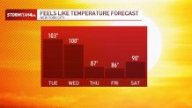
Temperatures are scorching this week. Highs across the region continue to climb into the 90s through Wednesday, as heat indices are expected to spend hours the triple digits.
Watch NBC 4 free wherever you are
But there is more in the forecast than just high temperatures and oppressive humidity. Strong storms are expected to fire up across the tri-state area later Tuesday and again the next day, a path to reprieve from the relentless heat and humidity gripping the region.

Get Tri-state area news delivered to your inbox with NBC New York's News Headlines newsletter.
Here's a day-by-day breakdown of what to expect through the middle of the week:
Tuesday

Some approached record highs Tuesday, with another hot and humid day to get through Wednesday.
Weather Stories


Tuesday’s heat also brought another chance for showers and storms, as early as the evening commute, thanks to daytime heating increasing instability.
A severe thunderstorm watch was in effect for nearly the entire tri-state area until 10 p.m. Storms started coming in at 5 p.m. for western portions of New Jersey; severe thunderstorm warnings were issued for parts of NYC and neighboring counties throughout the evening.
A more organized line of showers and storms pushed into the area around dinnertime. Some of those storms were powerful, leading in part to New York Gov. Kathy Hochul declaring a state of emergency for the entire state due to the damage caused by those storms upstate.
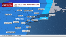
The main threats with this round of storms are damaging wind gusts, large hail and minor flooding. The hail could measure up to an inch in diameter, which could lead to property damage. Those within the risk area should park vehicles in covered areas is if possible, as hail of that size could crack a windshield or dent a roof.
The main flood threat is concentrated in the Hudson Valley, most likely to impact Sullivan and Ulster counties.
Wednesday
Despite the unsettled weather, these storms will not do anything in terms of providing relief from the heat and humidity; that does not come until late Wednesday with the passage of a cold front.
Wednesday begins like any other day this week: feeling brutally hot.
Scattered showers will start to pop up by the afternoon, continuing into the evening and overnight. The entire day is not a washout, but you could get caught in some pockets of heavy rain at times. Make sure to keep the umbrella close.
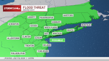
These storms also have the potential to be severe, producing damaging wind gusts and some minor flooding.
The storm timing may make the evening commute a little difficult, especially if you get caught in a downpour on the drive home. Exercise extra caution if your commute involves driving over low lying or flood prone roadways. And never drive through standing water.
In need of relief
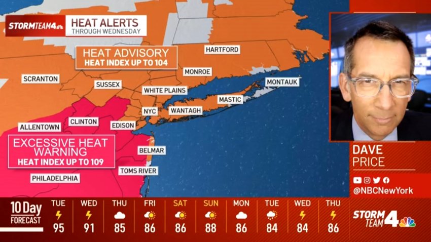
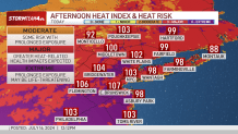
Meanwhile, the entire tri-state area is under heat alerts through Wednesday. North Jersey, the Hudson Valley, Connecticut, Long Island and New York City could experience feels-like temperatures up to 104 Tuesday and Wednesday, while Central and South Jersey could feel closer to 109 by midweek.
This level of heat, especially when it is prolonged for multiple days, makes it incredibly difficult for the body to cool itself. It is best to avoid strenuous activity, limit time spent outdoors and stay hydrated.
Check the latest weather alerts for your neighborhood here.

Looking ahead
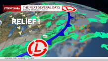
Once the showers and storms clear out early Thursday, both temperatures and humidity will see decline significantly.
Highs will be back near July averages and humidity will return to a tolerable level. This will make the end of the week, much more enjoyable than the start.

Track any approaching storms using our interactive radar below.