Hope you got to enjoy the pleasant weather earlier in the week — there won't be much sun to enjoy until the next one.
After a short break from the precipitation overnight and until around lunchtime Wednesday, rain returns in the afternoon. Some heavy downpours are possible later in the afternoon and into Thursday.
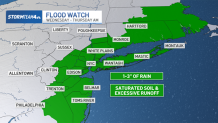
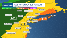
A widespread 2 to 3 inches of rain is expected, with locally higher amounts possible.
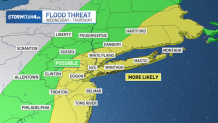
A flood watch has been issued for a large portion of the tri-state area from 1 p.m. Wednesday until 6 a.m. Thursday. While the morning commute will mainly be drizzly and foggy, the evening commute will be impacted. There is a potential for widespread minor flooding, with some areas possibly seeing more significant flooding.
Get Tri-state area news and weather forecasts to your inbox. Sign up for NBC New York newsletters.
Showers will just be approaching by midday, and the heavier rain will develop by Wednesday evening. The biggest flooding risk is for areas east of NYC, on Long Island and parts of coastal Connecticut, where the highest rain totals will be.
Weather Stories

New York City issued a travel advisory for Wednesday into Thursday, as some flood-prone roads may become impassable during the evening commute. The primary flood threat is set to end around midnight, though residual flooding is possible through the morning, the city's Emergency Management Department said.
The wet weather continues Thursday, which will be windy, as gusts pick up a bit. Isolated flooding is a concern beginning Wednesday night.
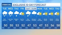
The lone decent day looks to be Friday, which will be dry. But after three days of rain, much of the ground will still be waterlogged, so not exactly ideal conditions for heading to the park for a picnic.
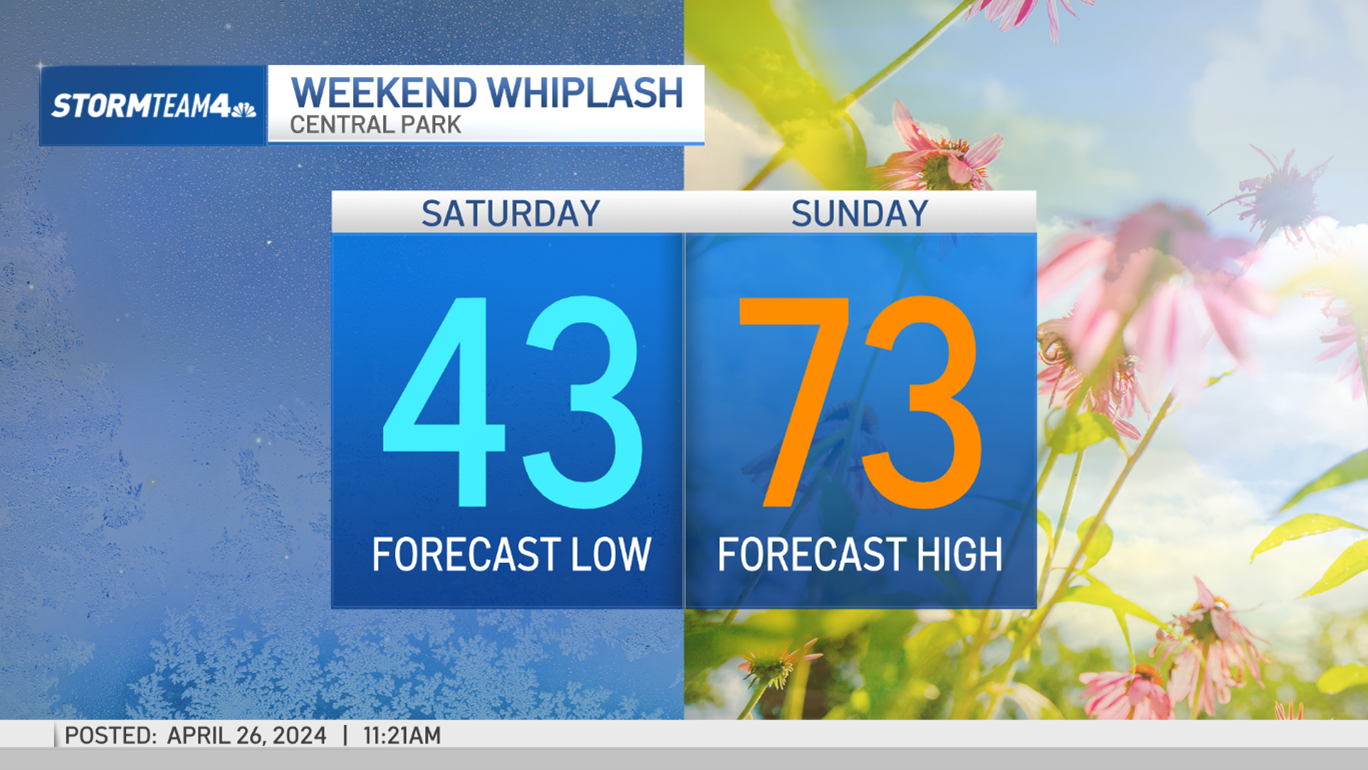
If you're looking for that relief from the rain to last over the weekend, don't get your hopes up. More precipitation could come Saturday as well as Sunday.
If there is some good news, it's that it will be far too warm for any snow to develop. The high temperatures each day will be in the mid 50s, eliminating any chance for a late-season snowstorm (at least for now).
Next week will start off gusty and chilly before a warm-up arrives just before midweek. Some of the wind chills Monday will make the commute feel January-like. But it does get better after that.
Check out the 10-day extended forecast and our interactive radar below.