The calendar says June, so getting some summer -- and stormy -- weather shouldn't come as much of a surprise. But that won't help keep you cool on Friday.
Friday was one of the warmer days we've seen this year, with highs peaking around 90 or higher in the early afternoon. Poughkeepsie appeared to get the hottest, reaching 95 degrees at its peak, as it was expected that spots north and west of New York City would be hotter. Teterboro Airport reached 92 degrees by 3 p.m., according to the National Weather Service.
Closer to the city, both Newark and Central Park reached 91 degrees — so it was a warm one no matter where you were in the tri-state. Places closer to the shore, like Islip, only climbed just above 80 for the day. Thankfully, low humidity levels meant no heat index to factor into the sweltering equation.
With all that heat came the chance for showers and thunderstorms, which arrived in the evening. Bouts of heavy rain and even hail were reported throughout the NYC area, as the hail reached up to an inch and a half in size.
Get Tri-state area news and weather forecasts to your inbox. Sign up for NBC New York newsletters.
Severe thunderstorm warnings were issued for much of NYC and neighboring counties during the peak of the evening rush, as the heavy downpours made their way through. Much of the rain in the city lasted for about two hours or so.
A couple thousand customers in Rockland County lost power during the evening, after a spokesperson for Orange and Rockland Utilities said a lightning strike from a squall took out two circuits, impacting customers in the Spring Valley area. The utility was hopeful to get power restored later in the evening.
The storms downed trees in Westchester County and led to delays of two hours or more at JFK Airport and Newark Airport. LaGuardia Airport fared slightly better, only seeing delays of 45 minutes as a result of the storms.
Check the latest weather alerts for your neighborhood here.
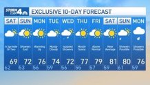
Showers and stormy conditions may linger into Saturday, but the weekend forecast is looking much drier than it did earlier in the week. Temperatures will be much cooler, with highs near 70. Most stay dry after light showers move out early. The sun breaks through a bit late Saturday and Sunday, which will be a gorgeous day in the 70s.
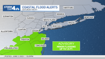
There is a chance for some minor coastal flooding with the full moon Saturday night, but wouldn't expect anything too out of the ordinary.
The next chance for showers is Wednesday, but the rest of the week looks pleasant through next weekend, with highs near average in the mid to upper 70s.