
Latest Forecast From Storm Team 4
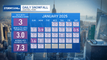
January 2025 has been unusually cold. We have spent days on end where temperatures never got above the freezing mark. But despite having the cold air in place, we haven’t been getting much snow to come along with it.
That is thanks to how little precipitation we have had this month. To date, 2025 has brought us our driest January on record in Central Park. And records go back to the 1860s, so that’s saying something.
Less than half an inch of liquid-equivalent precipitation has fallen. Majority of that fell as snow, adding up to just three inches.
Watch NBC 4 free wherever you are

Get Tri-state area news delivered to your inbox with NBC New York's News Headlines newsletter.
But January is not over yet and there is still the chance to pick up additional snow. For some of us.
A parade of low pressure systems are moving across the tri-state this week, set to bring rain, snow and even some ice to parts of our area, though to varying degrees of impact and intensity. Wednesday, Friday and Sunday are the days to keep an eye on.
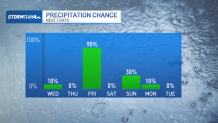
Wednesday’s precipitation comes from a weak clipper passing to the north. This system will bring some light snow accumulation across the Catskills and the Hudson Valley. In the places that manage to see snow, less than an inch will be common. However, well north and at the higher elevations, 1-3 inches of snow is possible with locally higher amounts.
Weather Stories

The track of this system does not favor getting any snow to Central Park. At best, a passing flurry is possible. Otherwise, the impacts of this clipper are largely confined to the north.
Timing tends toward late Tuesday night into Wednesday morning. Don’t expect steady snow showers the whole time, but anticipate some reduced visibility and slick road conditions for the morning commute.

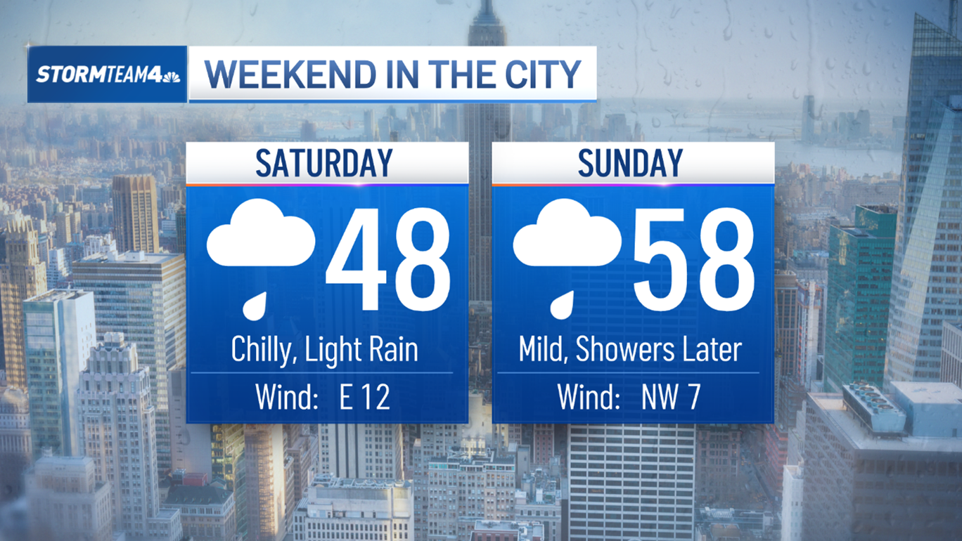
Friday’s precipitation will be far and away the most impressive. But thanks to temperatures well above freezing in Central Park, we’re looking ahead to all rain in the city. Further north and west, where temperatures are cooler, an icy glaze is possible at the onset before switching over to rain. The region is unlikely to get any snow from this.
But it will be a decent soaking. We are primed to see more rain in Central Park on Friday alone than we have seen over the course of the entire month so far. Dust off your umbrellas and rain jackets, you’ll want to grab both before heading out the door on Friday.

Sunday is our final precipitation chance on the horizon. But, once again, snow is looking increasingly unlikely for the city. Current forecast data suggests some light snow at the onset of the system that will switchover to rain. The shift to rain will greatly hinder any chance for accumulating snow since anything that falls, meager as it will already be, will melt from the subsequent rain.
After Sunday, we’re in for a dry stretch of days. We’ll have to wait until we get a little further into February before another chance for snow comes up.