What to Know
- The tri-state area has grappled with several bouts of snow following the nasty nor'easter that dumped more than 2 feet of snow on parts of the region earlier this month
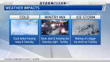
- Sunday offers a brief break between weather systems before a light wintry mix moves in overnight, threatening to cause some slick spots on the roads by Monday morning
- Storm Team 4 is monitoring a potentially high impact ice event late Monday into Tuesday morning with the greatest chance of widespread ice accretion north and west of the city
Valentine's Day offers the tri-state a brief break between weather systems before new threats bring a mix of rain, snow and ice to the region over the coming days.
Storm Team 4 is monitoring a potentially high impact ice event expected to arrive late Monday and hang around into Tuesday morning. But before that, a light wintry mix moves in Sunday night threatening to cause some slick spots by Monday morning.
The stronger winter storm approaches Monday evening. With cold air locked in place to the north, snow may mix with and chance to freezing rain, causing dangerous travel and the potential for power outages.
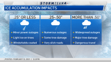
The greatest threat of widespread ice accretion over 1/4 of an inch looks to be in areas north and west of New York City.
Most of the incoming systems should clear out by lunchtime on Tuesday, Storm Team 4 predicts.
At this point, it's too early to forecast potential ice accumulations or tri-state impacts for those events, so stick with Storm Team 4 for the latest. Chances for additional precipitation in the tri-state area come on Thursday and Friday next week. Check the latest weather alerts for your neighborhood here.

Get Tri-state area news and weather forecasts to your inbox. Sign up for NBC New York newsletters.
Ice storms can be particularly perilous because they glaze over roads and other outdoor surfaces in ways that may be difficult to see for drivers and pedestrians. Even seemingly insignificant amounts of ice could damage trees and weigh down power lines as well.

In Fort Worth, Texas, overnight sleet this week made for treacherous driving conditions that led to a massive pileup involving at least 133 vehicles on an interstate highway. At least six people died and dozens were injured -- an indication of just how dangerous ice and sleet storms can be.
Concerns about the upcoming forecasts come as the tri-state wrapped up yet another snow event Thursday, one that saw more than 5 inches fall in spots on top of the 9 inches that fell in areas on Sunday. All that followed a powerful nor'easter that dumped more than 2 feet of snow on spots earlier this month, and has left nearly 34 inches of snow in Central Park this year — already 10 inches above average for the entire season.
Track the precipitation using our interactive radar below.


