What to Know
- Temperatures climbed to at or above 90 degrees across the tri-state area on Tuesday -- and with that came the threat of severe weather
- Heavy rain is expected for most in the NYC area; severe storms will continue to hit during the evening rush, starting out west and making their way to the southeast
- Flash flooding isn't a big worry with this system because it will be fast-moving, but lightning and damaging straight-line winds are key threats
Strong thunderstorms started to besiege the tri-state area Tuesday evening, with some storms having the potential to trigger squall-like conditions -- sudden, violent wind and rainfall -- in and around New York City during the evening rush that could severely hamper travel.
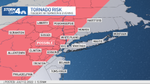
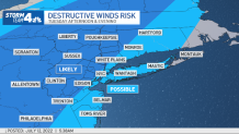
Lightning, torrential rain and damaging straight-line winds are likely for a large swath of the tri-state, though the more severe conditions are expected north and west of the five boroughs at this point. Large hail and tornadoes aren't likely but can't be ruled out, with a tornado warning triggered for Morris, Sussex and Warren counties in New Jersey earlier in the evening.
Flooding is less of a concern because the storms are expected to be fast-moving and even though they will likely produce heavy rain they aren't expected to linger long enough over any isolated areas to pose a significant flash flood threat. Most areas will see less than an inch of water accumulate by the time the system moves out.
Get Tri-state area news and weather forecasts to your inbox. Sign up for NBC New York newsletters.
Western and central New Jersey saw their risk of severe weather increase by early Tuesday afternoon, so people in those areas should be especially aware of the skies.
Several severe thunderstorm warnings were issued for parts of the Hudson Valley and into northwestern New Jersey through the early part of the evening. Severe thunderstorm watches are in effect for Dutchess, Sullivan and Ulster counties until 8 p.m. and for nearly every other county in the tri-state (except Long Island) until 10 p.m.
Stay weather aware! Check alerts for your neighborhood here.
The storms started to hit the further reaches of the tri-state — the areas around the Poconos and the Catskills — after 3 p.m., and will continue to sweep through the area well into the night. The system moved over northern New Jersey and the lower Hudson Valley between about 4 p.m. and 6 p.m., which led to some reports of damage, including a downed tree near I-80 in Warren County.
By sundown, New York City had yet to see any real impacts from the storms, though the severe weather threat extends well into the night. But it did mean many commuters were spared a wet walk home, but the fate of the Yankees game at the Stadium was still up in the air.
The last to see parts of the system should be those in Long Island and along the Jersey Shore, as the storm will pass through those areas later on while making its way to the south and east.

The rough weather comes along with an approaching cold front after a Tuesday that featured soaring humidity as actual temperatures top 90 degrees in Central Park.
If it feels like you're hearing the phrase "severe weather threat" lately, you're not alone. The northeastern United States is now in the climatological peak of its severe weather season. Overall risk should start to begin to wane later in the summer.
Breaking Down Tuesday's Severe Weather Threats
The storms will develop along an approaching cold front sliding in from the northwest. A line of thunderstorms (a squall line) will develop along that front and race through the area. The system could produce heavy rain, but won't hover over any one location long enough to be a real flood threat, as it will be moving through too quickly.
Tornadoes aren't likely but a spin-up twister can't be ruled out with this system.

After the Storms
Unfortunately, the storm front will not usher in a nice, refreshing air mass after moving on.
The weather stays hot on Wednesday, with highs expected to top 90 degrees again in the New York City area. Temps drop back into the high 80s on Thursday, when some spotty showers are possible, and should fall into the more seasonable mid-80s Friday.
Then the mercury climbs up again ahead of what at this point looks to be another warm and mainly sunny weekend. Saturday looks to be the ideal day, as the chance for thunderstorms returns on Sunday.
Overall: Summer will be in full force over the next 10 days, with temperatures consistently above the average high of 85 degrees, and humidity present for most of those days as well.
Track any approaching weather using our interactive radar below.