Heavy rain is expected to besiege the tri-state area Tuesday during what appears on track to be the closest to a full-day washout the region has seen in some time.
The most intense rain was expected through Tuesday morning, though it continued at a slow and steady pace over much of the day. Up to 4 inches of standing water could accumulate in spots by the time the system moves out.
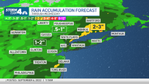
It's the type of rain that could improve severe drought conditions plaguing New York, New Jersey and Connecticut this summer, but also the kind that will likely lead to ponding of water if not significant flooding.
Get Tri-state area news and weather forecasts to your inbox. Sign up for NBC New York newsletters.
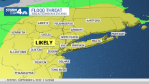
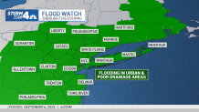
Flooding -- flash floods and flooding in poor drainage areas -- is the primary concern, especially in areas north of New York City, though much of the region is vulnerable. Check the latest weather alerts for your neighborhood here.
The MTA says it has crews prepared to handle transit-related issues that may emerge amid the heavy rains, including pre-positioned weather-response teams in the subway system and crews poised to assess safety and restore potential track issues on Metro-North and Long Island Rail Road lines. Get real-time commute updates from all your key sources here.
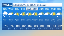
Showers linger into Wednesday, and a strong east-northeastern flow combined with a nearly full moon will likely cause minor coastal flooding from Long Island to the Jersey Shore starting with Wednesday's afternoon high tides.
Overall, Wednesday looks cloudy, cool and breezy, with scattered showers, before the rain finally clear out completely Wednesday night.
Sunshine and warmer temps return by the end of the week. Temps stay in the low-to-mid 70s through Wednesday then climb to around 80 Thursday, back above average for this time of year as NYC kids return to the classroom. The warm and mostly sunny trend in the low 80s sticks around through the weekend, but watch out for potential rip currents on ocean beaches starting Friday.
10-Day Forecast
Track any approaching storms using our interactive radar below.