
At least there's one rollercoaster open year-round.
The New York area is bracing for a blast of the wintriest weather it has seen yet in the 2022-23 season, though, that's not saying much, of course, given the record-breaking daily heat that just "scorched" some spots a week ago.
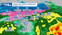
While Monday morning was the first time Central Park dipped into the 30s, expect that to become a pretty regular thing over the next stretch. Temperatures will drop even colder Tuesday morning, potentially triggering new freeze watches from the National Weather Service. And the highs during the day will be lower as well, not getting out of the mid-40s.
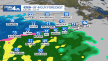
A chilly rain moves in by Tuesday's evening commute, with some snow mixed in north and west. Other spots could see an icy or wintry mix. Higher elevation areas and spots that see the coldest temps are more likely to see some white stuff, but no significant accumulation -- or really, measurable accumulation at all -- is expected with this system.
Get Tri-state area news and weather forecasts to your inbox. Sign up for NBC New York newsletters.
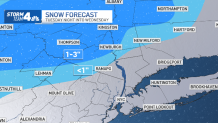
Areas far north and west of the city could see up to 3 inches accumulate through Wednesday, but most of the tri-state area will get less than an inch of snow if any. New York City isn't expected to see snow at all, this map shows.
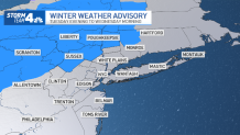
The National Weather Service issued a winter weather advisory for Dutchess, Orange, Sullivan and Ulster counties in New York, Sussex County in New Jersey and Pennsylvania's Pike County, warning of the potential for up to a tenth-inch of ice between Tuesday afternoon and mid-morning Wednesday on top of the snow. Driving may be hazardous and sidewalks will be slippery.
Additional Hudson County valleys could be added to the advisory Tuesday, so be sure to check here for the latest weather alerts in your neighborhood.
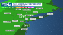
Meanwhile, up to 2 inches of cold and soaking rain are expected to sweep through NYC, Long Island, most of New Jersey and coastal Connecticut.
What to Expect Tuesday Night
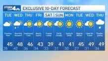
For the most part, the weather will clear out by Wednesday afternoon. Sullivan, Ulster and Orange counties in New York might see a wintry mix early Wednesday, so commuters are advised to take extra precautions on the roads and rails. It could be slippery early. Some in those counties saw a couple of surprise snowflakes fall Sunday -- a weak, if not highly-anticipated first "snowfall." Wednesday won't bring much either.
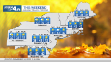
But we also won't be going back to those 70-degree November Saturdays. Temperatures in New York City stay below 50 degrees for the foreseeable future, and highs for Saturday may not make it out of the 30s. The holiday travel outlook looks good though, for now, though rain may be possible on Thanksgiving (but hopefully does not arrive until after the parade).
10-Day Outlook
Track any approaching precipitation using our interactive radar below.
