
National Weather Service experts confirmed Wednesday that a tornado touched down in a New Jersey community as a line of severe weather rolled through the day before -- and we're slogging through yet another round of precipitation.
The Lawrence Township twister on Feb. 21, 2023, was quite a weather rarity, though not unprecedented. It is one of only five tornados to hit the Garden State in the month of February since 1950.
The EF-2 tornado made landfall at 3:35 p.m., and traveled just under six miles along a path about 200 yards wide, according to the NWS. The 110-115 mph max wind speeds traveled west from Lawrence into neighboring Quaker Bridge in Mercer County, before the short-lived tornado stopped at 3:41 p.m.
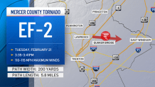
The NWS said that a continuous path of tree damage was seen near Lawrence Station Road, particularly at a housing development on Fountayne Lane, as well as roof damage at a development at Lawrence Square. There was further tree damage at a nearby golf course and another commercial building.
Videos showed winds strong enough to toss a trampoline into a driveway and rip the siding off homes. Trees fell on multiple homes and cars throughout the area.
Get Tri-state area news and weather forecasts to your inbox. Sign up for NBC New York newsletters.
No injuries were reported.
Local


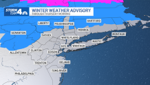
In the wake of the exceedingly rare weather event, a winter weather advisory was in effect for Sullivan, Ulster and the eastern portion of Dutchess counties until 10 a.m. Thursday. Light icing is likely in higher elevations, making driving conditions during the morning rush in those areas tricky.
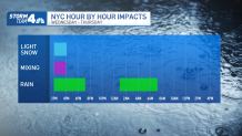
Other areas were slated for a cold rain overnight and through the mid-morning. Precipitation should move out after that, leaving quiet and unseasonably warm weather for the remainder of the day. Temperatures rise above freezing later Thursday morning, which will help melt any lingering ice.
We're looking at cooling temps Friday -- down to about 45 from above 50 on Thursday -- and even more cooling Saturday, when highs are expected to barely top the freezing mark. Winds will gust to near 30 mph Friday, so it will quickly feel like winter again as people head home from work, as temperatures dip into the 30s in the afternoon and into the 20s overnight.
Wind chills could be in the teens to start the weekend once again, and it'll stay breezy and chilly through Saturday. While it will be cold, the wind will be weaker than on Friday.
By Sunday, we're back to above-average temperatures. We're tracking yet another storm system that could hit in a week or so, but at this point, it's too hard to predict how it could impact the tri-state area. For now, expect rain and stay with Storm Team 4 for all the latest weather developments.

Track any approaching precipitation using our interactive radar below.
