
Latest Forecast From Storm Team 4
The post-July 4 forecast looks to be anything but a holiday.
The heat and humidity are here, and we’re not expecting much relief anytime soon. There's a bit of good news coming off of a couple back-to-back heaters: the heat advisory is no longer in place as of Sunday.
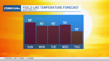
Despite that "reprieve," it will still stay plenty hot. The air remains sticky, stuffy and warm with "feels like" temperatures still in the low to mid 90s for most of us.
Watch NBC 4 free wherever you are
NYC OPENS COOLING CENTERS ON SUNDAY -- CLICK HERE FOR DETAILS

Get Tri-state area news delivered to your inbox with NBC New York's News Headlines newsletter.
But even with slightly cooler temperatures, the entire region is getting in on the brutal level of humidity. And that’ll leave you feeling sticky regardless of what the air temperature is.
Weather Stories

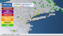
On top of the heat, there's another reason to limit any strenuous outdoor activity, especially if you have a respiratory condition. An air quality alert is in place from 11 a.m. to 11 p.m. Sunday for parts of New Jersey, New York and Connecticut.
Rain chances go down significantly on Sunday, thanks to the passage of a “cold” front.
Unfortunately, the front does not come with a significant cooldown. High pressure builds in behind the front on Sunday.
We’ll enjoy a mostly rain-free day, but temperatures will remain in the upper 80s to low 90s for much of the area. Dew points, while slightly below Saturday’s levels, will still be high.

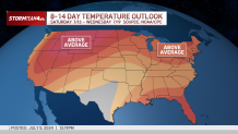
We keep the rain-free skies through Monday, but storm chances return on Tuesday and linger through much of next week. As for temperatures, they’re showing no signs of dropping significantly anytime soon.

Track any approaching rain or storms using our interactive radar below.