
What to Know
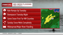
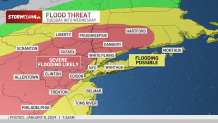
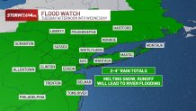
- The tri-state area is expected to get a significant amount of rainfall in the 2 to 4 inch range from midday Tuesday through early Wednesday morning. The rain will fall on top of up to a foot of snow cover in some interior locations leading to flooding concerns
- Wind gusts will get above 50 mph is some areas, leading to power outage worries, especially on the Jersey Shore and Long Island. Storm Team 4 is predicted widespread major river flooding throughout the area. New Jersey Gov. Phil Murphy has declared a statement of emergency beginning at 5 p.m. on Friday. New York City has issued a travel advisory for the the duration for the duration of the storm
- Once we get through Tuesday's storms and the impacts from that, we are watching another rain system for Friday night into Saturday
The New York area is bracing for its second major winter storm of the season, as many who live north and west of the city work to dig themselves out from the last one, which dumped more than a foot of snow in spots this weekend.
It was enough to close or delay schools across the Hudson Valley and trigger winter storm warnings for a swath of the region.
The approaching system doesn't threaten more of the white stuff, so Central Park's nearly two-year snow drought continues -- but heavy rain, especially on top of the weekend snow cover, is expected to make it an impactful storm.
Get Tri-state area news and weather forecasts to your inbox. Sign up for NBC New York newsletters.

New Jersey Gov. Phil Murphy has declared a state of emergency beginning at 5 p.m. on Tuesday.
New York City issued a travel advisory for the duration of the storm warning about the difficulty of travel and getting around during the peak of the rain Tuesday evening.
Tuesday will bring heavy rain starting by late morning, and getting heavier through Tuesday night. Temps will climb into the 50s, and that, combined with the heavy rain, will lead to rapid snow melt.
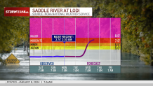
Widespread river flooding is expected across New Jersey and the lower Hudson Valley, particularly the areas with snow cover. Some may be severe.
Track the rain and wind forecasts hour by hour.
New Jersey dealt with extensive flooding in late December, and many are still struggling with the damage.
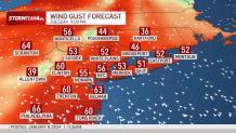
Winds will also be a concern, with gusts topping 50 mph on Tuesday night. Power outages and downed trees can be expected, especially on the Jersey Shore and the South Shore of Long Island. Gusts could also be particularly problematic on Staten Island. The rain should wind down before Wednesday's morning commute, but high winds are expected to linger.
A high wind warning will be in effect starting Tuesday at 6 p.m. through Wednesday morning for Staten Island, Brooklyn, and parts of Queens, Suffolk, and Nassau counties in New York. In New Jersey, Monmouth, Ocean, Cumberland, Atlantic, and Cape May counties are subject to the high wind warning. The southern half of Fairfield County in Connecticut is also under the warning.
More weather stories


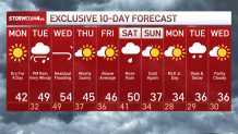
What's next? Check out the 10-day forecast
Once the next mess moves out, we're looking at warmer temperatures Wednesday as well as residual flooding. The weather briefly improves for the end of the week, with mostly sunny skies and above-average temperatures Thursday.
More rain could return as early as Friday evening. Thunder is also possible. This one could begin briefly as wintry precipitation for far northwest counties. Another significant batch of rain could be part of the system this weekend.
Next weekend looks iffy at this point, but there's plenty of time for the forecast to change. Sign up for our newsletters here.
Track any approaching precipitation using our interactive radar below.
