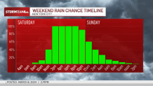
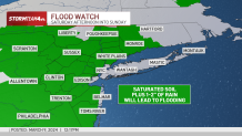
It's another wet weather weekend for the tri-state, particularly the first half, as flood watches have been issued for neighboring counties of New York City.
Rain started to pick up by the early afternoon Saturday — and it wasn't expected to stop for hours.
Flash flood watches had been issued for nearly all of New Jersey, along with the Lower Hudson Valley and southern Connecticut, from 1 p.m. Saturday through 8 p.m. Sunday.
Get Tri-state area news and weather forecasts to your inbox. Sign up for NBC New York newsletters.
Weather Stories

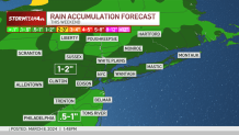
Despite the watches issued, flash flooding itself was not likely — but river flooding from excessive runoff was very possible, thanks to up to 2 inches of rain runoff over an already saturated ground. River flooding will likely extend into Sunday, since it takes a long time for the water to drain all the way through the network of rivers to the ocean.
Ponding and minor street or urban flooding were likely at the “usual suspect” areas during times when rain is heavy. So anywhere that floods frequently during rain storms (looking at you, Hoboken and certain parts of Queens) could see some problems. This flooding should be gone by the overnight hours.
Check the latest severe weather alerts for your neighborhood here.
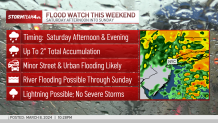
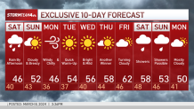
If there is some good news, it's that it will be far too warm for any snow to develop. The high temperatures each day will be around 50, eliminating any chance for a late-season snowstorm (at least for now).
Next week starts off gusty and chilly before a warm-up arrives just before midweek. Some of the wind chills on Monday will make the commute feel January-like. But it does get better after that.
Check out the 10-day extended forecast and our interactive radar below.