
What to Know
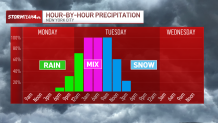
- A powerful winter storm descended on the tri-state area overnight, and is expected to transition from rain to snow in time to make the Tuesday morning commute treacherous
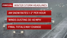
- Snowfall rates up to 2 inches an hour are possible with this system; with 1” per hour, road conditions can deteriorate pretty quickly, though recent warmth and the preceding rain could mitigate that
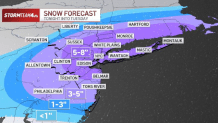
- A widespread 5 to 8 inches of snow are expected for the immediate NYC area, with locally higher amounts possible
Heavy, wet snow is falling across the New York City area Tuesday morning with many school districts announcing closures or remote learning days as the storm impacts promise to be widespread.
The system started as rain for most, falling in New York City overnight ahead of the transition, though snow was falling in earnest well before the peak morning commute got underway. Track the snow with StormTracker4 here.
Snowfall rates of 1 to 2 inches an hour are possible during Tuesday's morning rush. That could make for whiteout conditions at times and perilous driving along the I-95 corridor from Philadelphia to Boston.
Get Tri-state area news and weather forecasts to your inbox. Sign up for NBC New York newsletters.
Road conditions deteriorate rapidly even with snowfall rates of an inch an hour -- and snow may fall at three times that rate across eastern Pennsylvania, northern New Jersey and the Hudson Valley at the peak of the storm. It was falling at quite a clip in Times Square early Tuesday. Check out our live cam from the Crossroads of the World.
Snow totals could reach 8 inches for the city, northern New Jersey, Long Island, the Hudson Valley and nearly all of Connecticut. Areas further north and west of the city could see less, as could central New Jersey and the Jersey Shore, where 3 to 5 inches are expected.
Isolated spots in areas like Suffolk County on Long Island and New Jersey's Sussex County could see higher totals.
News

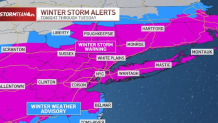
The National Weather Service issued a winter storm warning by Monday afternoon for most of the region, including New York City, Long Island, the Hudson Valley, Fairfield County in Connecticut, and Bergen and Hudson counties in New Jersey. A travel advisory for the city takes effect Tuesday. Check weather alerts here.
New York City schools announced they would go fully remote Tuesday in anticipation of the storm, and Mayor Eric Adams urged everyone who could to stay home. Yonkers schools are closed. Check school closings and delays.
"We're strongly encouraging New Yorkers: if you don't have to go out, stay home, and please use public transportation," Adams said Monday. "We want to minimize the number of vehicles on the road so that our apparatus and vehicles can actually deal with the removal of snow and make our movement in the city more feasible."
When will it start snowing?
Precipitation began late Monday as rain and will transition to snow in the New York City area during the morning commute. The storm will bring a period of moderate to heavy snow.
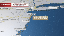
Gusty winds and minor to moderate coastal flooding impacts are possible. The coast could see gusts up to 50 mph at times, with widespread gusts up to 30 mph expected inland.
The snow is expected to taper off before the evening rush, but lingering impacts are likely.
How much snow will we get?
Warmer temperatures, rain and sleet could cut down the snow totals for New York City and coastal areas -- but colder temperatures or a southern shift in track might elevate them. Storm Team 4 is currently forecasting 3 to 5 inches of snow for New York City and Long Island. A travel advisory for the city takes effect early Tuesday.
Cancellations and delays were mounting at local airports, especially LaGuardia, which had called off nearly 400 scheduled flights before 8:30 a.m.
The Hudson Valley and interior areas of New Jersey, Pennsylvania, and Connecticut are likely to get heavier amounts. High-end snow totals could reach 8 inches at higher elevations.
It's important to note that New York City and the nearby coastal areas could see more snow if temperatures trend colder on Tuesday. Coastal flooding, meanwhile, is also a concern with this system.

New York City suspended alternate side parking regulations for Tuesday. Parking meters are in effect.
What can we expect for Valentine's Day?
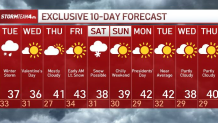
Once the storm moves through Tuesday, we can expect cool, but seasonable temperatures for the rest of the week.
Valentine's Day is expected to be partly sunny with highs in the 30s and lows in the 20s.
There's a chance of snow showers next Saturday, but it's too early to say anything definitive at this point.
See the latest forecast in your area anytime here.
