What to Know
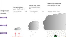
- Lake effect snow forms when cold air, often coming from Canada, moves across the open waters of the Great Lakes region; heat and moisture cause clouds to form, and those clouds grow
- Snow begins to fall, and heavy snow bands develop downwind from the lake; these snow bands are extremely narrow, though, making the forecast even more difficult to predict
- Anywhere from 1 to 4 feet of snow could hit Buffalo with this system, given the variability
The governor of New York has declared a state of emergency, with feet of lake-effect snow expected to wallop the Buffalo area through the weekend, threatening the Bills game and more as schools shut down en masse.
The National Weather Service predicts an absolute disaster starting Thursday, with travel expected to be "very difficult to impossible" through Friday evening, at least. Snowfall rates of 1 to 2 inches per hour are likely. Some spots could see snowfall rates up to 3 inches an hour at times, Gov. Kathy Hochul's office says.
Forecasters estimate 1 to 3 or more feet of snow could hit the region. A lake effect snow warning has been issued from 7 p.m. Thursday through 1 p.m. Sunday, Nov. 20 -- the exact time the Bills and Browns are scheduled to kick off.
Get Tri-state area news and weather forecasts to your inbox. Sign up for NBC New York newsletters.
That kind of weather could be blinding. It was earlier Thursday, too, as a snow squall, essentially a rapid, blizzard-like event, triggered a flurry of National Weather Service alerts.
No single location is expected to see heavy, heavy snow through the entire weekend, but the system will linger through Sunday, forecasters say, compounding travel and other hazards ahead of the Thanksgiving holiday travel rush. Ice and intense winds associated with the storm will only make matters worse for the Buffalo and Watertown areas.
The New York state Department of Transportation implements a full commercial vehicle ban at the following locations beginning Thursday at 4 p.m.:
- Interstate 190 - Route 62 to I-90
- Interstate 290 - full length
- Interstate 990 - full length
- Route 33 - full length
- Route 219 - Route 39 to I-90
- Route 400 - full length
- Buffalo Skyway Route 5 - full length
- I-81 - Exit 33 to Canadian border - trucks use right lane only
"Parts of Western New York, the Finger Lakes, Central New York and the North Country are about to get their first snowstorm of the season, which means we need everyone in these impacted regions to be ready for dangerous travel conditions," Hochul said in a statement. "My team and I are deploying emergency response assets ahead of the storm, remain in constant contact with local officials, and are laser-focused on the forecast. New Yorkers should remain vigilant ahead of the storm and avoid any unnecessary travel during these hazardous conditions."
So what is lake effect snow and why is it so dangerous?
What Is Lake Effect Snow?
According to the National Weather Service, lake effect snow is the term used to describe what happens when cold air, often coming from Canada, moves across the open waters of the Great Lakes region.
As it passes over the unfrozen and relatively warm waters, warmth and moisture transfer into the lowest part of the atmosphere, the air rises and clouds form. They grow into a narrow band that produces 2 to 3 inches of snow an hour.
The direction of the wind is critical in determining which spots get lake-effect snow, and that can be volatile.
Heavy snow may fall in one location while the sun shines in another a mile or so away. The physical geography of land and water is also important to assess when it comes to forecasting potential lake-effect impacts.
As the National Weather Service warned regarding this storm system, "Where the lake effect is most intense and persistent, the snow will be measured in feet, not inches."
Areas most heavily impacted could see what looks like a "wall" of snow at times. Check the latest weather alerts for your neighborhood here and track any approaching weather locally using our interactive radar below.