
What to Know
- Near-record heat hits Thursday ahead of potentially strong thunderstorms in the afternoon; the Mets postponed their home opener ahead of the anticipated weather
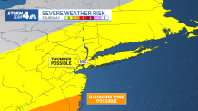
- We don't expect the kind of widespread tornado threat we saw Saturday, but damaging winds are possible south of NYC; storms could roll around rush hour but should mainly be out by sunset
- Easter weekend still looks spectacular
More rough weather may skirt along parts of the tri-state area Thursday night, which comes on the heels of a weekend that saw violent thunderstorms trigger multiple tornadoes in New Jersey and lightning strike the World Trade Center in Manhattan.
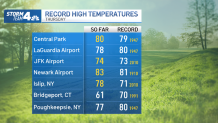
Throughout much of the region, Thursday was the warmest day of 2023 so far. Near-record temperatures in the 70s and even low 80s were seen in spots, especially inland areas and throughout New York City. Further east across Long Island and southern Connecticut had slightly cooler temperatures due to the onshore wind from the Atlantic.
It was the warmest day in more than six months for Manhattan, as Central Park tied its record high of 79 degrees set back in 1947. Later in the day, Newark Airport topped its previous high of 81 — set more than a century ago, back in 1910! Islip and JFK also reached new record highs for the day, both of which broke records from 2010.
Get Tri-state area news and weather forecasts to your inbox. Sign up for NBC New York newsletters.
That heat may help trigger potential late-afternoon thunderstorms, though increased atmospheric stability since Wednesday has downgraded the severe weather risk a bit for the region. The storms are also expected to start later than initially forecast, and much of the storms will end up hitting the southern edge of New Jersey.
We are still expecting rain, but it should be showers and run-of-the-mill thunderstorms for parts of the evening, with the threat lasting until around 11 p.m. Stay with Storm Team 4 for all the latest weather developments.
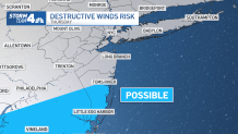
There could be some damaging winds around coastal and southern New Jersey, where multiple communities are still struggling to clear debris from Saturday's tornadoes. Much of the rest of the tri-state will just have the risk of thunderstorms.
Straight-line winds are possible further south, but no widespread tornado threat, as was the case over the weekend, is expected. Hail is unlikely. Sign up for our newsletters here.
The weather led the New York Mets to postpone their scheduled Thursday home opener at Citi Field against the Marlins until Friday at 1 p.m., which now looks to be in great shape.
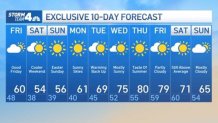
What's Next? Check Out the 10-Day Forecast
Temperatures fall closer to normal once the system moves out, but we should still see highs in the low 60s for what should be a largely sunny Good Friday. Temps dip a bit cooler Saturday and we'll see mainly cloudy skies. It'll be dry, though, and sunshine abounds for Easter Sunday, with highs expected in the mid-50s.
We've got gorgeous weather to kick off the start of next week, with mostly sunny skies and temps approaching 70 by Tuesday ahead of another summer-like warm-up that could see it hit 80 degrees by Thursday.
More News


Track any approaching precipitation using our interactive radar below.
