What to Know
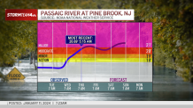
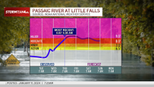
- Most rivers recede through the day Thursday, but the Passaic River is expected to stay at major flood stage for days, leaving flood-weary residents vulnerable in multiple communities
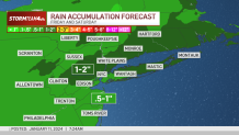
- Up to 2 inches of rain is possible in some areas. A coastal flood watch goes into effect Saturday for some areas; 15-foot waves could lead to erosion and high water level concerns
- We're tracking the potential for accumulating snow potential Monday into Tuesday
More rain -- and winter -- is in the forecast heading into the weekend, as parts of New Jersey face the ongoing risk of major river flooding and some New York residents battle to dig themselves out of a relatively fresh foot of snow.
First, a Friday night into Saturday storm could cause a bump in river levels. This incoming system is projected to bring far less rain than Tuesday's storm, so flooding is not expected to be as dramatic as it was earlier in the week for most.
Get Tri-state area news and weather forecasts to your inbox. Sign up for NBC New York newsletters.
The good news: We should see improvements area-wide in terms of floodwaters on Thursday. The not-good news: The Pompton, Passaic and Housatonic rivers will be the exception and are forecast to stay in a major flood stage for days.
Major river flooding concerns in New Jersey
Tuesday's storm knocked out power to hundreds of thousands along the East Coast as it dumped a widespread 2 to 4 inches of rain on the already saturated metro area. Many schools were delayed, and some districts closed for the day.
Local


Inland flooding is possible again with the upcoming storm. Showers approach by late Friday afternoon and steadier rain takes over in the evening. Thunder is possible, with the heaviest rain and gustiest rains expected in the late Friday to early Saturday hours.
Those near the Passaic River are most at risk for flooding, including residents in Pine Brook and Little Falls. That river could exceed current levels and approach levels -- 18 to 24 inches -- last seen during the heavy flooding on Dec. 20.
Gov. Phil Murphy addressed the media after touring flood sites in Little Falls on Thursday. He expressed gratitude there were no reports of fatalities and injuries associated with the latest storm.
Murphy pledged relief to those already in need as well as those who may find themselves in need, saying, "We are here for you, period. We're in one of these cycles, whether we like it or not -- and we just have to get through it."
The Democrat also said that ultimately, the risk level has to change, adding, "We're getting dragged by Mother Nature, so whether it's mitigation, resiliency programs, it's pretty clear we need to do a lot more."
The Saddle River at Lodi, which was among the districts to close schools Tuesday, is expected to continue to recede from major flood stage and should be well below minor by Friday morning. Expect just a slight bump in water levels.

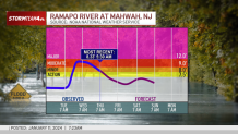
The situation at the Ramapo River at Mahwah continues to improve Thursday, reducing the risk for the next system.
A coastal flood watch will also be in effect this weekend. Waves will be up to 15 feet early Saturday, so more erosion and high water levels are likely.
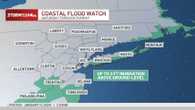
A new flood Watch has been issued for parts of New Jersey in anticipation of rain Friday night into Saturday morning.

Winds will not be as strong with this weekend's storm as Tuesday night but still could gust up to 55 mph on the Jersey Shore.

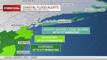
There are coastal flood alerts in place for Saturday's high tide cycles, particularly long the South Shore of Long Island and the Jersey Shore.
Track the rain using our exclusive StormTracker 4 interactive radar below.
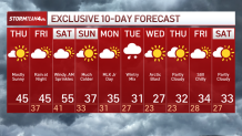
What's next? Check out the 10-day forecast
We're looking at temperatures in the mid-40s Thursday and Friday. Sprinkles and strong winds from the Friday/Saturday storm linger into Friday morning and temperatures warm up to 55 for a daily expected high.
Then it gets really cold. By Sunday, expect it to feel like winter outside. And come the middle of next week, we're talking temps in the 20s. We're tracking the potential for accumulating snow Monday into Tuesday, though more should be clear in the coming days. Sign up for our newsletters here.