What to Know
- The coldest air since last February moves in this weekend behind that storm system, and temperatures aren't expected to climb above the freezing mark until Monday
- The cold blast comes after snow hit the tri-state on Friday, with most of the area getting 1 to 3 inches, but up to 5 inches for areas in New Jersey
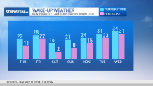
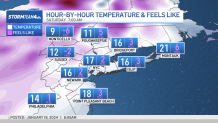
- Temperatures will barely get into the 20s on Saturday and won't reach above freezing until Monday — and it will feel even colder with the painful wind chills
The third winter storm in roughly a week slammed the tri-state area Friday, dumping more than 5 inches of snow in spots before ushering in the coldest air the region has seen in nearly a year.
The snow started during the morning commute and lingered throughout much of the day, finally tapering off by the time of the evening rush hour for most.
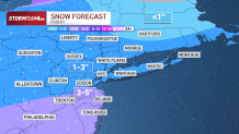
Winter storm warnings were issued in New Jersey, which got hit the hardest, especially along the Jersey Shore and Ocean County. A widespread 1 to 3 inches of snow was expected for areas closer to the city. Given the frigid air, the system was an all-snow event and did lead to a number of school closures and early dismissals. See the latest severe weather alerts here.
Get Tri-state area news and weather forecasts to your inbox. Sign up for NBC New York newsletters.
Even though it lasted for most of Friday, the storm was similar to the one earlier in the week which was barely enough to break Central Park's 701-day snow drought.
How much snow will we get?
Local


In the city, most areas had seen about half an inch to just over an inch of accumulation by the time the storm moved on. Central Park got just under half an inch, while LaGuardia Airport got about 1.3 inches.
Other areas around the city saw similar totals, from 1-3 inches overall.
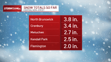
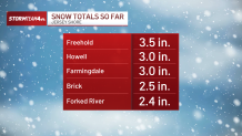
Parts of New Jersey had seen more snow by the evening. Here are some totals from around the state as of 4:15 p.m.:
So what's next?
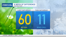
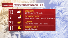
The incoming system will bring the coldest air since last February behind it. Saturday will be the coldest day, with wind chills in the single digits. Expect more of the same for Sunday.
Expect overnight lows in the teens and highs on Saturday to barely reach the 20s — and with the wind chill, it will feel even colder.
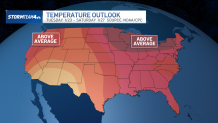
Sunday will be a bit warmer, but the tri-state won't see temperatures above the freezing mark until Monday. The good news is once is finally reaches above-freezing, it stays there for the foreseeable future, as temperatures will be far more tolerable (in the 40s) for much of next week.
We climb back above freezing by Monday, and then we thaw out for a while. At least we can see a finish line.
Deep freeze
Face-numbing 'feels like' temperatures
Extended weather outlook
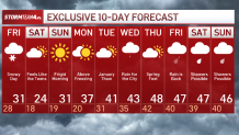
Next week's national picture