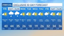
The tri-state can expect more moderate temperatures Friday and Saturday ahead of snow Sunday evening and a bone-chilling start to next week.
We can expect mostly sunny skies on Friday with temperatures finally breaking the freezing mark. Highs will be near 40 degrees, which is much closer to the mid-January average than we have been seeing.
Saturday will also be more mild, but less dry with some rain making its way into our area. We could see temperatures approach the mid-40s but rain will start mid-morning and pick up during the afternoon. The showers will be more scattered than widespread in nature.
Watch NBC 4 free wherever you are
All eyes are on Sunday and the chance for up to five inches of snow possible starting later in the day and carrying through until early morning.
Get Tri-state area news delivered to your inbox with NBC New York's News Headlines newsletter.
The day begins cloudy but dry – with temps climbing above freezing mid-day Sunday. Temps fall to freezing by the time snow arrives in the evening – with much colder air coming overnight into Monday.
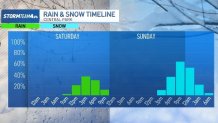
A widespread 3-5" is possible Sunday night across the tri-state, including Connecticut, New York City, Long Island, Westchester and much of New Jersey.

The snow should stick around a while with much colder temperatures Tuesday/Wednesday including wind chills that may fall below zero.