
What to Know
- Chilly rain sweeps over the tri-state area Tuesday evening; it'll be a soaker for Long Island, NYC, most of NJ and coastal CT; north and west counties might see light snow and ice accumulation
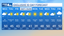
- Once the system moves out, expect cold and windy weather for the rest of the week, with temps in the low 40s and possibly capping out in the 30s come Saturday
- As for Thanksgiving itself, a developing storm will move across the country next week, but won't reach the tri-state until Black Friday — meaning it will be clear for the parade, but it will bring rain for holiday shoppers
Remember when it was sunny and in the 70s like a week ago? Well, now we have the first snow of the season. Fun.
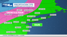
The tri-state area got its first relatively widespread winter blast Tuesday evening, and it's expected to last into Wednesday morning. The system will likely bring a messy mix of precipitation, though what kind depends on where you live.
A chilly rain started to move in to the area by Tuesday's evening commute, with some snow mixed in north and west. Other spots got an icy or wintry mix. Higher elevation areas and spots that see the coldest temps were more likely to see some white stuff, but no significant accumulation -- or really, measurable accumulation at all -- was expected with this system.
Get Tri-state area news and weather forecasts to your inbox. Sign up for NBC New York newsletters.
What Kind of Weather Will You Get?
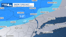
How Much Snow?
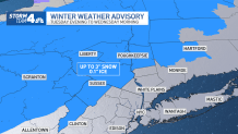
Areas far north and west of the city, in the Catskills and the Poconos, got up to 3 inches into early Wednesday morning. Most of the tri-state area got less than an inch of snow, if any. New York City wasn't expected to see snow at all, and got entirely just rain through Tuesday night.
Ice accumulations of up to a tenth of an inch could also make travel difficult Wednesday for the north and west suburbs. A winter weather advisory remains in effect for multiple counties in the northern Hudson Valley, as well as Suffolk and Warren counties in New Jersey. Check the latest severe weather alerts for your neighborhood here.
Rainfall Predictions
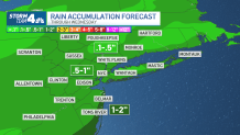
The five boroughs, most of New Jersey, Long Island and coastal Connecticut will continue to see mainly rain overnight, but it will get lighter as the night wears on and should taper off around sunrise. Much of the area will see less than an inch of the cold, soaking rain before Wednesday morning.
Showers taper off early Wednesday but the cold, breezy conditions remain. By Friday, temperatures cool back to the 40s and a reinforcement of even colder air slides in for the weekend, with the first freeze expected for NYC.
Weather locally, and generally across the country, stays quiet through the big Thanksgiving travel rush, which should be noneventful (at least weather-wise) around the northeast. Conditions will stay dry, warming to near 50 by Thanksgiving.
As for the holiday itself, a developing storm will move across the country next week, but won't reach the tri-state until Black Friday — meaning it will be clear for the parade, but it will bring rain for holiday shoppers. Stay with Storm Team 4 for the latest details.
10-Day Outlook
Track any approaching precipitation using our interactive radar below.
