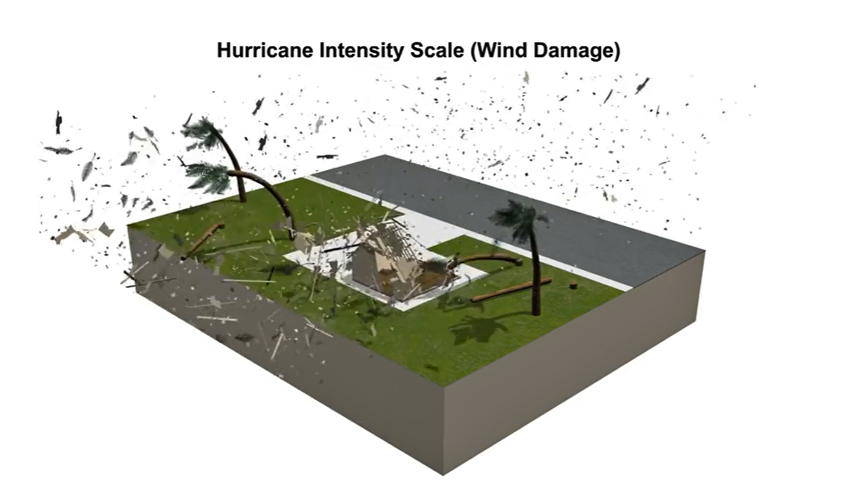
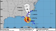
Hurricane Ian made landfall as a catastrophic category 4 storm Wednesday as the "extremely dangerous eyewall" moved onshore in Florida, bringing potentially deadly storm surges, devastating winds and widespread flooding in what forecasters described as a life-threatening situation.
Ian made landfall in Cayo Costa, Florida at 3:05 p.m, ET, the National Hurricane Center said. Its 150 mph max wind speed fell just short of making it a category 5, but the storm did tie for the fifth most-powerful to make landfall in U.S. history.
Catastrophic wind damage was expected where the core of Ian moved onshore, which occurred sooner than initially predicted. Multiple reports came in of on-land wind speeds exceeding 100 mph, and videos showed debris sent flying by the powerful gusts. From Fort Myers to Naples to Sarasota, the worst is far from over.
Get Tri-state area news and weather forecasts to your inbox. Sign up for NBC New York newsletters.
Hurricane-force winds extend outward up to 45 miles from Ian's center, and tropical-storm-force winds extend outward about 175 miles, NHC says.
Rainfall Potential
Perhaps even more than the strong winds, what experts and officials fear the most may be the flood threats stemming from the hours of torrential rainfall and dangerous storm surge. Rainfall totals won't be known for many areas until the storm fully moves through, but one spot just east of Fort Myers reported more than 14 inches of rain by Tuesday evening.
Widespread prolonged major and record river flooding is expected across central Florida. Considerable flooding is expected for southeast Georgia, coastal South Carolina, and up into North Carolina, NHC says.
The flood threat will stick around for some time as well. A large portion of central Florida, stretching from Tampa east to Orlando and almost up to Jacksonville is in line for 10-15 inches of rain during the days-long onslaught from Ian, with some areas on the eastern shore potentially getting deluged with 20 inches or more. Locally, up to 30 inches is possible, the NHS said.
Flash Flood Risk
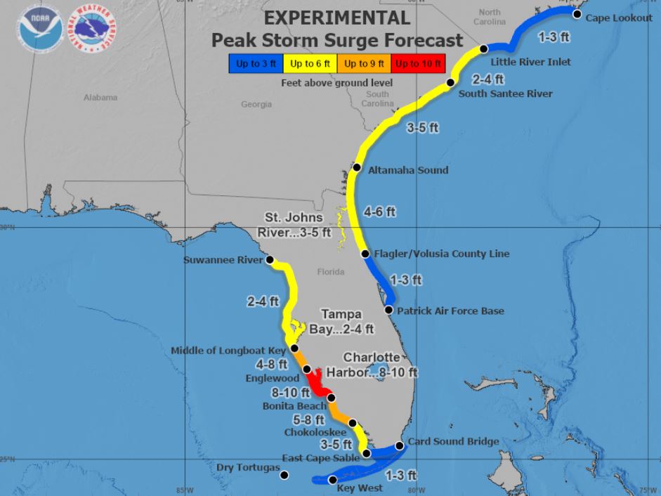
Combine that with storm surges up to 10 feet in some cases, as it was for the coastal area around Fort Myers, and it made for more than enough water to inundate low-lying coastal communities. The damage was seen in videos from multiple areas where roads turned into rivers, with cars bobbing in the water and other items floating away.
Widespread catastrophic flash, urban and river flooding is expected to last late into the week across central and northern Florida, as well as some southern areas. Those flooding concerns stretch up to Georgia as well as the Carolinas along the coast later in the week and through the weekend.
Peak Storm Surge Forecast
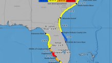
The deepest water will occur along the immediate coast, near and to the right of the center, where the surge will be accompanied by large waves, NHC says. Surge-related flooding depends on the relative timing of the surge and the tidal cycle and can vary greatly over short distances, so people are advised to check their local weather offices for details.
Nearly two million Florida residents were without power by Tuesday night, and that number will climb exponentially.
Hurricane Ian Causes Power Outages Throughout Florida
As Hurricane Ian makes landfall in Florida, power outages are expected to grow across the state. The Category 4 hurricane has brought catastrophic winds and flooding to the state.
Source: PowerOutage.us
Credit: Andrew Williams / NBC
The storm steadily weakened in the hours after making landfall, going down to a Category 1 before midnight, with sustained winds down to 90 mph by 11 p.m. However, Ian could still be near hurricane strength when it moves over Florida's east coast Thursday, and when it approaches the northeastern Florida, Georgia and South Carolina coasts late Friday, NHC said.
The unrelenting assault from Ian is expected to last for another day in Florida, the National Hurricane Center said in its 2 a.m. update. The center of the storm, which will continue to weaken over the next day or so, will move across the center of the state overnight and well into Thursday. The storm should emerge over the western Atlantic, off Florida's eastern shore, by late Thursday, according to the NHC.
It will then turn toward the north and could make landfall again, this time as a tropical storm, around Savannah, near the Georgia-South Carolina state border. Tropical storm warnings are in effect from just north of Daytona Beach, all the way up the eastern seaboard up through Wilmington, North Carolina. A hurricane watch is in effect from the Daytona area up to the South Santee River, north of Charleston.
A hurricane warning remains in effect on the Gulf Coast side of Florida from Bonita Beach to the Anclote River, including Tampa Bay. There is also one in effect for the eastern side of the state, from the Sebastian Inlet to the Flagler/Volusia county line.
Those on Florida's east coast could see hurricane conditions starting overnight, and those remain possible in areas under a hurricane watch through late Friday, according to NHC.
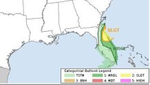
Other tropical storm and storm surge warnings and watches are in effect for a host of locales in Florida, Georgia, South Carolina and North Carolina, to varying degrees. Check here for the latest. Multiple tornadoes are possible across the Florida peninsula.
Tornado Risk for South Florida
"This is not just a 48 hour ordeal. This is going to be something that is going to be there for days and weeks and months and unfortunately, in some circumstances, even years," said Florida Gov. Ron DeSantis.
He declared a state of emergency well before the storm arrived. Now Georgia, South Carolina, North Carolina and Virginia are similarly declaring states of emergency before the storm arrives at their doorstep, as Ian makes its slow march north.
The governor and President Joe Biden are said to be in "close coordination" in regard to the storm and possible federal assistance that could be needed afterward.
"Your safety is more important than anything. And I know our hearts are with everyone who will feel the effects of this storm," Biden said.
This latest weather threat comes just over a week after Hurricane Fiona devastated Puerto Rico and the Dominican Republic.
Communities in southern parts of Puerto Rico were inundated with torrential rain and wild winds, amounting to more than 2 feet of water in spots as the threat of deadly mudslides loomed. Lago Cerillos, not far from Ponce, where Fiona made landfall in Puerto Rico ahead of a second landfall in the Dominican Republic a day later, saw nearly 3 feet of rain.
President Joe Biden declared a state of emergency for Puerto Rico ahead of the storm, while the governor of Puerto Rico, as the worst of it hit, described "catastrophic" damages as the island plunged into darkness.