
The streak of brutal cold weather continues with no significant break in sight -- and Storm Team 4 says it may get worse.
Storm Team 4 is tracking an even colder shot of air than the blast that froze New Yorkers' glove-covered fingertips Monday. Temperatures Friday morning may plunge to near zero, including in midtown. Central Park's last recorded temperature of 0 degrees was in January 1994.
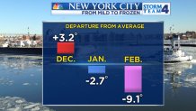
This winter started off mildly, by comparison. December's average temperature was 3.2 degrees above the norm. In January, the weather turned a bit colder, but it wasn't extreme. The average temperature for January was 2.7 degrees below average.
The arctic ax dropped on the tri-state area in February -- several times. Central Park is currently running 9.2 degrees below average. With 11 days left in the month and no significant warm-up in sight, February 2015 will likely go down among the 10 coldest on record.
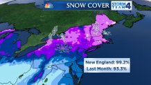
One factor playing into the extreme cold is the amount of snow blanketing the country. With nearly half of the United States under at least 1 inch of snow, the arctic air masses originating in Siberia and Canada have not be able to warm before they arrive.
[[292231571, C]]
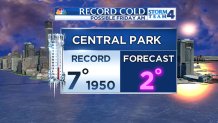
Central Park dipped to 3 degrees Monday morning, marking the coldest temperature in more than a decade. It was last that cold on Jan. 16, 2004, when the temperature dipped to 1 degree. The next round of bitter cold arriving Thursday night into Friday may smash records. The record low for Feb. 20 in Central Park is 7, set back in 1950.
Storm Team 4 is forecasting a low of 2.
Slightly warmer air will try to push into the area Saturday night into Sunday, but that will come at the price of a wintry mix. Temperatures will rise into the mid-to-upper 30s with the chance of snow, sleet and freezing rain.
