
What to Know
- A tricky nor'easter dumped as much as 17 inches of snow in parts of the Hudson Valley, to just trace amounts in NYC; the Hudson Valley saw the heaviest snow, along with northern New Jersey
- The governors of New York and New Jersey issued states of emergency ahead of the storm, implementing commercial vehicle restrictions on highways and mobilizing emergency personnel
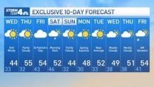
- The snow tapered off overnight, but we're looking at strong winds Wednesday; the weather improves after that in a serious way (if you don't believe us, look at the 10-day projected highs below)
The strongest nor'easter of the season besieged the tri-state with wave after wave of snow and/or rain (depending on your location) over the course of a roughly 36-hour siege that only began to wrap up early Wednesday -- and that still leaves us .
Any lingering snow had turned to sporadic flakes overnight, following Tuesday's steady, consistent snowfall, but temperatures plunged, meaning roads could be icy in spots Wednesday, especially in areas that got more snow.
Get Tri-state area news and weather forecasts to your inbox. Sign up for NBC New York newsletters.
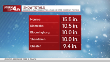
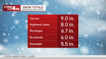
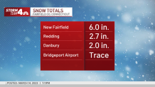
Parts of the Hudson Valley and northern New Jersey got more than a foot of it -- and it was heavy, power-crippling snow that had more than 34,000 tri-state customers in the dark and disrupted travel plans for millions in the Northeast.
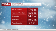
Here's a look at some of the biggest totals from around the tri-state, with New York's Mount Carmel seeing the most as of Tuesday evening — at 17 inches!
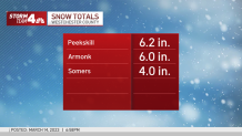
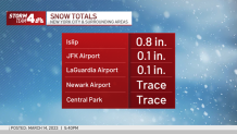
New York City was once again left out of the snow party. Central Park recorded just a trace and other parts of the five boroughs notched maybe some slush. A bit further inland, the lower Hudson Valley, Westchester and Fairfield counties saw anywhere from 2 to 6 inches of snow. Spots that saw more rain first saw lower totals.
Here's a look at some of the snow totals closer to NYC:
Though the snowfall totals likely won't set records even in the hardest hit areas, it'll be so heavy that a foot and a half would feel more like 3 feet. Gov. Kathy Hochul, whose hometown of Buffalo was ravaged by its deadliest snowstorm in decades late last year, declared a state of emergency ahead of the storm. She also activated the National Guard to assist as needed.
New Jersey Gov. Phil Murphy later also declared a state of emergency for five counties in the Garden State (Morris, Bergen, Sussex, Passaic and Warren), saying, "this is a foot of snow, so this could be a meaningful storm."
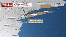
The precipitation will die down overnight into Wednesday, but strong winds will remain a big concern — and not just for the areas that saw heavy snow. Some of the strongest winds have been reported along the Jersey Shore, which was largely bereft of snow but still had plenty of wind and rain, as gusts topped 50 mph in some spots.
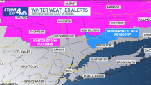
A wind advisory is in effect into the overnight hours. Gusts of 40-50 mph are likely throughout the night for coastal areas in New Jersey, Connecticut and on Long Island. Those powerful gusts will drop wind chills into the 20s and teens by Wednesday morning. The day will start windy and struggle to get much above the low 40s, though it will be dry and sunny.
Nearly 14,000 tri-state customers were without power as of 10:30 p.m. Most outages were Central Hudson customers in counties like Duchess and Putnam, where winter storm warnings were in effect until late Tuesday. Connecticut, which started the day out light in that regard, saw nearly 7,000 Eversource customers still in the dark by Tuesday night, while New Jersey reported just a couple hundred outages overall.
Check the latest school closings and delays here.
Commutes through Wednesday morning will likely be mucked up region-wide as a result of the storm. (Obtenga todos los detalles en español aquí.)
Hochul's emergency order will remain in effect for impacted counties, as additional snow and especially the wind will produce hazardous travel conditions through Wednesday morning. However, New York State Police and the state's Department of Transportation lifted all previous restrictions on tandem and empty tractor-trailers that began Monday evening.
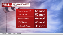
LaGuardia, JFK and Newark airports each reported fewer than 100 flight cancellations as of 9 a.m. Tuesday. Two-and-a-half hours later, that number had climbed to more than 200 at LaGuardia and more than 100 at Newark. Regionally, more than 800 flights had been canceled and 1,500-plus delayed by 11:15 a.m.
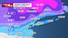
Temperatures tick back up the rest of the week, with highs expected in the 50s Thursday through Saturday and a cloudy but dry forecast for New York City's annual St. Patrick's Day Parade Friday. The chance for rain returns late Friday into Saturday morning. And spring starts next week. Sign up for our newsletters here.
More News


Track any approaching precipitation using our interactive radar below.
