
Get ready for big weather changes over the next couple of days.
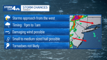
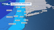
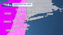
Beginning Thursday night, a line of storms are expected to move through the area from around 9 p.m. to 1 a.m.
The storms are expected be much stronger as they approach from the west and will weaken in New Jersey and as they pass east over New York City and Long Island. However, there is a slight risk for damaging wind, as well as hail.
Get Tri-state area news and weather forecasts to your inbox. Sign up for NBC New York newsletters.
Storms will be offshore shortly after midnight and then we will be in the clear for the rest of the night.
Friday will start very muggy and warm, with temperatures spiking near 90 degrees. It’s a short-lived hot spell, as a front moves through in Friday afternoon and drier cooler air begins to filter into the tri-state. Temperatures on Saturday are expected to be in the cool 60s with gusty winds.
It will be a sunnier Father's Day as dry skies and warmer temperatures (mid-70s) will great us.
News

The Juneteenth holiday will also bring us pleasant temperatures in the upper-70s with partly cloudy skies.
