


TODAY — Pictured: Rockefeller Plaza on Thursday, January 4, 2018 — (Photo by: Nathan Congleton/NBCU Photo Bank/NBCUniversal via Getty Images via Getty Images)
What to Know
- Rain and snow arrived in the NYC area Thursday afternoon and lasted into Friday evening; the Hudson Valley saw up to 8 inches of snow. Gusty winds are likely, too
- The city got mostly rain, before the coastal system wound down Friday night, paving the way for a dry but chilly weekend
- There's another storm chance that could bring snow in the lead-up to Christmas weekend, though the forecast is too far out at this point to be sure
A long-duration winter storm extended its battering of the New York area Friday with a mess of snow, ice and rain that threatened to bury parts of the Hudson Valley under up to 8 inches of the white stuff and inundating coastal areas with flooding downpours.
The bulk of the volatile system, which just blasted the south and Midwest, arrived in the late afternoon and evening hours Thursday, bringing rain to many — but some say nearly 5 inches of snow by midnight. Check the latest weather alerts for your neighborhood here.
Those areas to the north and west of NYC continued to see waves of snow well into Friday afternoon, bringing totals in some areas of Orange, Sullivan and Ulster counties of New York to as much as 8 inches (Kiamesha Lake, NY, had the highest total as of Friday night at 8.3 inches). Other parts of the Hudson Valley and northern New Jersey saw more than 7 inches of snow.
Get Tri-state area news and weather forecasts to your inbox. Sign up for NBC New York newsletters.
Some totals were kept a bit further down than expected due to temperatures trending just a bit warmer (by 1 or 2 degrees, but that makes all the difference!), in the 33-34 degree range in Sullivan and Ulster counties, turning the snow to rain. Check more totals here.
The snowiest areas saw some school closings on Friday. Check those here.
By Friday night, the storm had by in large moved out from the tri-state area, save for a few lingering sprinkles or flurries in parts of Long Island or in the Hudson Valley.
As was the case with the storm earlier this week, coastal areas and spots in and around New York City stayed above the freezing mark and got almost exclusively rain, about 1-2 inches of it, through Friday afternoon. Wind gusts up to 50 mph, with sustained winds around 20 to 30 mph, lasted well into Friday as well.
No significant ice accumulations were expected with this weather event, but travel conditions became tricky to say the least, especially on Friday. Where heavy snow falls and gusty winds hit, power outages were a concern. Commutes throughout the region were impacted on Friday, with those in the city and on Long Island affected by rain and strong winds.
More Stories


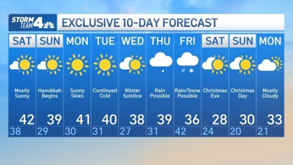
Locally, a few snow showers may linger north and west on Saturday morning, but the storm will be mostly done by then, leaving chilly weather through the weekend. Breezy conditions are expected Saturday, with sunny to mostly sunny skies and temperatures reaching the low 40s — though the winds will keep it feeling like the 20s for most of the day.
Temperatures will struggle to make it out of the upper 30s and low 40s as Hanukkah begins on Sunday — and they'll stay that way for much of next week. There is another storm chance next week that could bring snow in the lead-up to Christmas weekend, with potential for a major storm Thursday or Friday. But the storm has yet to develop and the forecast is too far out at this point to be sure. Stay with Storm Team 4 for updates.