What to Know
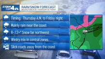
- Rain and snow are expected for the NYC area Thursday afternoon and lasting into Friday night; spots far north and west will see accumulation and we'll see gusty winds, too
- The city should get mostly rain, but a wintry mix is possible overnight and could make for rough travel Friday morning
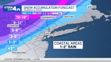
- Some areas could see more than a foot of snow, especially further north and west of NYC; parts of the Hudson Valley could see up to 8 inches, while the city can expect to get 1-2 inches of rain
UPDATE - Coastal Storm Eyes NY: Up to a Foot of Snow Possible for Some, Heavy Rain for Others
Just a few days after some in the New York City area saw their first measurable snowfall of the season, another storm is on tap — and could bring significant snowfall to parts of the region.
Expect more clouds overnight into Thursday before the storm arrives in the tri-state area. Those far to the west of the city could see flakes begin in the morning, but the bulk of the system, which is currently blasting the south and Midwest, is expected to arrive in the metro area in the afternoon.
Get Tri-state area news and weather forecasts to your inbox. Sign up for NBC New York newsletters.
On top of a messy mix of precipitation, winds should really ramp up, particularly along the coast and eventually out on Long Island. They should gust upwards of 30 mph Thursday and could get up to 50 mph along the coast Friday morning, as the storm threat lingers.
As was the case with the storm earlier in the week, coastal areas and spots in and around New York City will stay above the freezing mark and can expect mainly rain, about 1-2 inches of it, through Friday afternoon. Snow will accumulate in the upper Hudson Valley, as well as the Poconos and Catskills mountains to the far north and west of the city. Expect gusty winds there, too.
News


Because of the extended duration of the snowfall (Thursday through Friday night) accumulations close to a foot or even more are possible, especially further north or west of the city. In the northwestern part of New Jersey and in the Hudson Valley, anywhere from 3-8 inches can be expected. Snowfall and ice accumulation are the great concerns.
The greatest snow totals are likely to be found at higher elevations in the Poconos and Catskills, but we could see parts of the Hudson Valley pushing past 6 inches of snow, too.
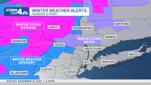
Winter storm warnings are in effect for Sullivan and western Ulster counties in New York, as well as Pennsylvania's Pike County from Thursday morning through Friday afternoon. Those areas could see 6-12 inches, with more than a foot in higher elevations.
A winter storm watch was issued for Orange County in New York. New Jersey's Sussex and Warren counties, as well as part of Passaic County and the eastern portion of NY's Ulster County, are under winter weather advisories. Any of those areas could see accumulations ranging from 0-6 inches, depending on location and elevation.
Check the latest weather alerts for your neighborhood here.
Inland areas just north and west of the NYC area will start with a wintry mix (snow, ice & rain) on Thursday, then as temperatures warm throughout the day that mix will change over to all rain by Friday.
While accumulating snow is unlikely for the city, we could get some mixed precipitation. Regardless, roads are expected to be slick Friday, so drivers are advised to take caution as commutes could be treacherous.
Through Wednesday, the huge storm system delivered blizzard-like conditions to the Great Plains and was expected to push more snow and ice into the northeast. Residents from West Virginia to Vermont have been told to watch for a possible significant mix of snow, ice and sleet. The wintery blast dumped more than 2 feet of snow in parts of South Dakota, and is part of the vast and volatile system ripping across the U.S. that killed at least three people in Louisiana.
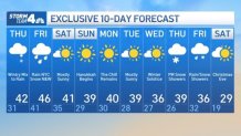
Locally, a few snow showers may linger north and west on Saturday morning, but the storm will be mostly done by then, leaving chilly weather through the weekend.
Temperatures will struggle to make it out of the upper 30s and low 40s as Hanukkah begins on Sunday — and they'll stay that way for much of next week.