


Latest Forecast From Storm Team 4
What to Know
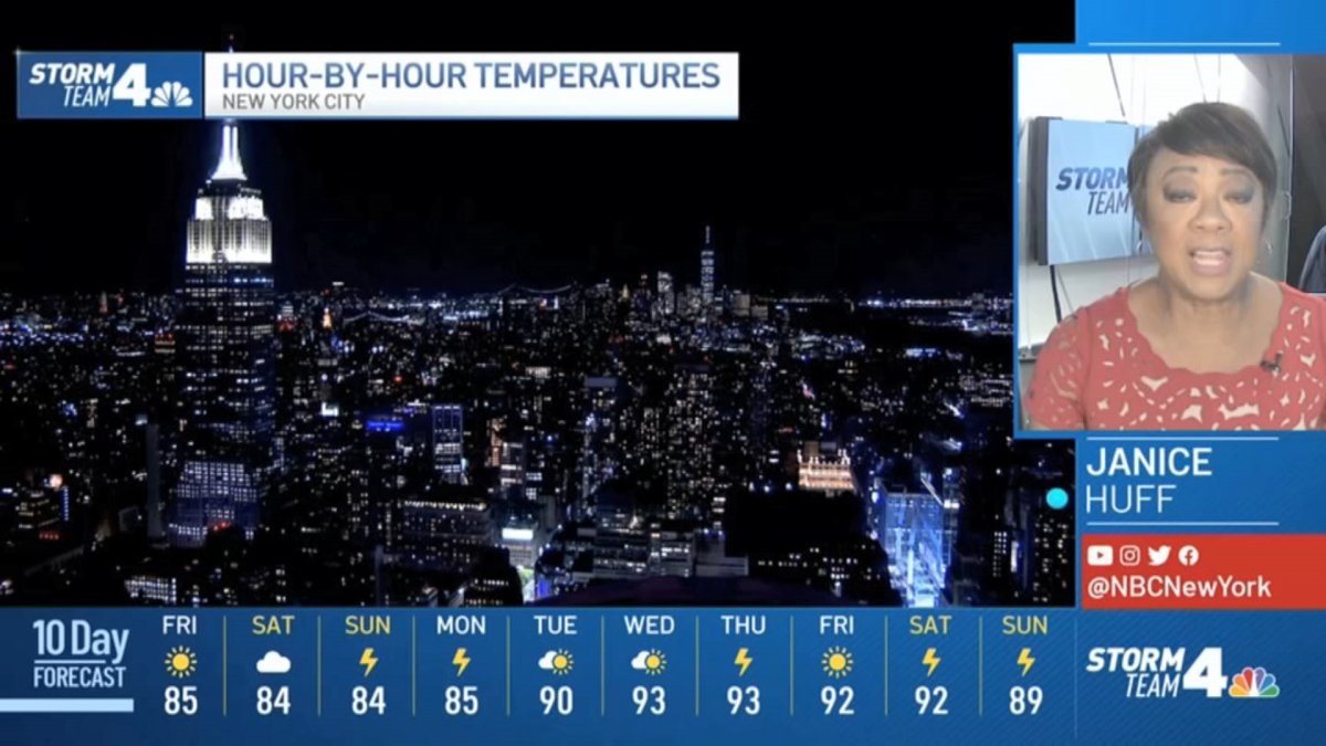
- After Thursday marked NYC's first heat wave of 2022, Friday sees pleasant weather in the mid-80s with lower humidity; the storm chance returns Sunday and Monday, though, ahead of another possible (and even longer) heatwave next week
- Isolated thunderstorms popped up once again Thursday, this time hitting Long Island, a day after intense cells slammed small pockets of Ulster County late Wednesday, leaving thousands without power
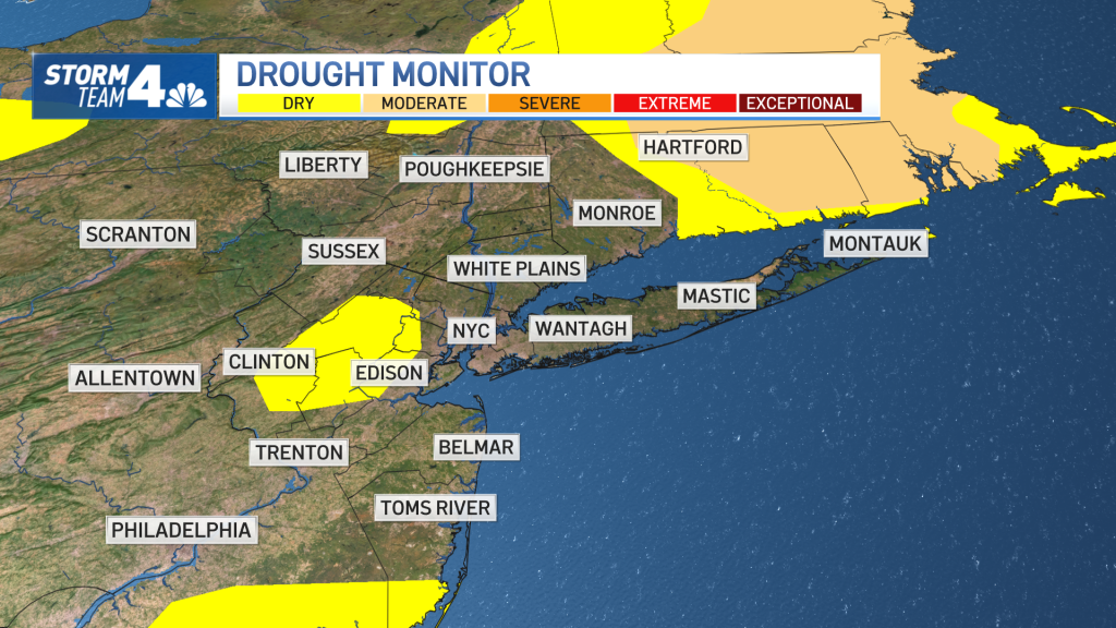
- More rain is actually needed in the tri-state, with some spots seeing abnormally dry conditions, according to Storm Team 4's drought monitor
New York City has its first official heatwave of the summer — and there may be another one right around the corner that's hotter and even longer.
With Thursday being the third straight day in the city where temperatures hit 90 degrees or above, it marks the first heat wave of 2022. Thursday's highs in the city reached 90 degrees in the mid-afternoon, after hitting 91 on Wednesday and 90 on Tuesday.
In addition to the heat, some tri-state residents once again saw another round of isolated-but-intense thunderstorms in the evening hours. A strong isolated storm triggered severe thunderstorm warnings for Suffolk County on Long Island around dinnertime, with a trees downed and power lost around the areas of Selden and lake Ronkonkoma. Check here for the latest severe weather alerts.
Get Tri-state area news and weather forecasts to your inbox. Sign up for NBC New York newsletters.
However, those isolated storm cells did not produce anything like the buckets of hail that walloped parts of New York so badly it looked like piles of snow were accumulating in some Ulster County neighborhoods.
Wednesday night's storms affected mainly Ulster County, where more than 11,500 customers remained without power by mid-morning Thursday. People in some parts of the country saw buckets of hail fall so quickly they piled into what looked like mounds of snow. Trees also were reported down in Dutchess and Ulster counties, with Kingston particularly hard-hit.
Although some are still reeling from that destructive system, any rain for the tri-state area would be quite welcome, given the region is starting to see "abnormally dry" conditions in spots.

Friday features more pleasant weather with highs in the mid-80s as the humidity lowers a bit, and it looks to stay around that level for a couple days. But the reprieve will be brief.
News


Smothering humidity returns with a vengeance by Sunday, which should bring actual high temperatures in the high 80s along with the threat of afternoon thunderstorms. Expect more unsettled weather in the high 80s and a storm chance Monday — which could bring heavier and more widespread rain to the area, a help for the current drought-like conditions.
The current forecast calls for five straight days of 90-degree or higher temperatures at Central Park starting Tuesday abd lasting into the weekend, which would mark the city's second heatwave in as many weeks. Stay with Storm Team 4 for the latest.
Track any approaching weather using our interactive radar below.

