
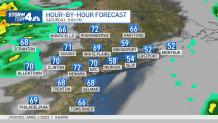
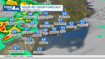
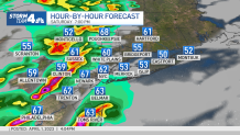
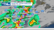
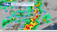
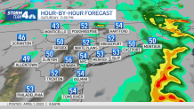
A squall line is on track to push through the tri-state area Saturday evening, bringing with it damaging winds with gusts topping 60 mph.
The risk of severe weather has grown as the arrival of the approaching storm system closes. The line of thunderstorms is expected to move through between 6 and 10 p.m.
Wind gusts remain the primary threat of Saturday's weather event, but a few additional threats, like large hail and tornadoes can't be ruled out.
Get Tri-state area news and weather forecasts to your inbox. Sign up for NBC New York newsletters.
The storm threat will likely end by Saturday night, around 10 p.m., as the cold front pushes through.
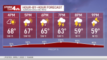
Here's a look at what we could see through Saturday night.
Hour-by-Hour Breakdown

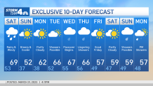
What's Next? Check Out the 10-Day Forecast
The front clears late Saturday, and, unfortunately, temperatures crash back into the 30s Sunday morning after highs near 70 on Friday. We should ultimately see Sunday highs in the 50s, though it'll still feel cool. The weather improves for Monday as highs climb back into the low 60s with partly sunny skies.
Showers are possible again Tuesday and through the middle of the week, with temperatures expected to linger in the mid-60s at least through Thursday.
Stay with Storm Team 4 for all the latest weather developments. Sign up for our newsletters here.
More News


Track any approaching precipitation using our interactive radar below.
