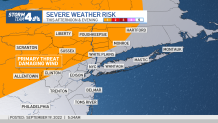
Summer-like temperatures return with a vengeance to kick off the workweek, with the mercury climbing near 90 degrees before a line of strong thunderstorms rolled through the tri-state later in the day.
Monday started out dry, but showers and storms — mainly north and west of New York City — started kicking up by the mid to late afternoon. By the time the evening rush hour was underway, the line of storms had hit the city, but were moving fast and only left quick downpours for a few minutes.
Some of the storms brought gusty winds as the cold front made its way through. Damaging winds were possible, but no severe weather was reported.
Get Tri-state area news and weather forecasts to your inbox. Sign up for NBC New York newsletters.
Check severe weather alerts for your neighborhood here and see radar and weather maps here.
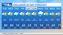
The rain will usher in less humid temperatures for Tuesday and Wednesday, both days which look spectacular, with highs around 80 degrees and plenty of sunshine.
Another cold front comes through for the first day of Autumn on Thursday, bringing our next chance of rain. A strong high pressure builds in behind it and brings in a lasting cooldown. Highs stay in the 60s for a few days, but the "warm-up" still forecasts below-average highs. The same front will also keep guiding Fiona away from the East Coast.
Expect highs to drop to the 60s Friday and Saturday and stay a touch below average through the early part of next week. Here's your 10-day outlook.