
What to Know
- Another storm is brewing that could bring more snow Friday into Saturday; this looks to be a mainly rain event for NYC, though precipitation is expected to be heavy at times
- The system should start at some point before Friday's evening commute and might initially be all snow, even in NYC, but it should transition to rain in the city and areas south at night; the situation for people in northern NJ, the Hudson Valley and Connecticut is a little more complicated
- Friday's storm follows a winter wallop that kicked off this week by dumping more than a half-foot of snow on parts of NY and mucking up two commutes; NYC saw a few inches from that system
A winter storm started its siege on the New York City area Friday evening with up to 2 inches of rain (and possibly a few flakes) expected to come by the time the system moves on — while dumping nearly a half-foot of snow on spots far to the north and west over the course of roughly 12 hours that won't end until Saturday morning.
A wintry mix started to move in to the city by the end of the evening rush hour, with the heart of the storm hitting later Friday night and lasting into the overnight hours. The heavies rain should end by 4 a.m., though bad travel conditions can be expected until sunrise, regardless of what kind of precipitation is falling
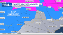
Winter weather advisories have been issued for western Ulster, eastern Dutchess and Sullivan counties in New York as well as Pike County in Pennsylvania. The line for higher expected snow totals shifted farther north over the last day or so, meaning more mixing and rain is expected in these spots than previously. Winter storm warnings will be in effect for the areas shaded pink in the map below. Check the latest National Weather Service alerts here.
Get Tri-state area news and weather forecasts to your inbox. Sign up for NBC New York newsletters.
Tri-State Breakdown: What to Expect Where You Live
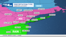
NYC AND LONG ISLAND
- 1-2” of rain, some thunder possible late Friday
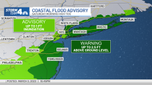
- Coastal/tidal flooding, some to moderate levels by Sat AM; localized rainfall flooding possible
- 40 mph or higher wind gusts on Long Island
- National Weather Service says breaking waves of 7-11 feet along the oceanfront in Suffolk County are possible, which could result in significant beach flooding and erosion
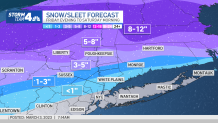
NORTHWEST NJ, CATSKILLS, LOWER HUDSON VALLEY AND SOUTHWEST CONNECTICUT
- A mix of snow/sleet/rain
- Best chance for problematic ice accumulation will be Pike/Sullivan/northern Orange counties
- Best chance for more snow than mix will be northern Sullivan, Ulster and Dutchess counties
SOUTH OF NYC AND JERSEY SHORE
- 1-2” of rain
- Wind gusts to 50 mph near the coast, strong enough to cause localized tree damage and power outages
- Minor to moderate coastal flooding for Sat AM high tides, making some roadways impassable; rainfall flooding possible
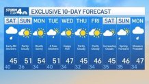
What's Next? 10-Day NYC Weather Forecast
Things could change, of course, so stay with Storm Team 4 for all the latest forecast developments.
The storm will move out early Saurday with lingering Hudson Valley snow showers through midday.
Once the winter storm moves on, clouds will stick around for Saturday as temperatures stay in the 40s. There may be some lingering showers, too. Sunday looks to be the better day, with mostly sunny skies and highs around 51 degrees.
Next week looks cool and quiet apart from a possible quick burst of precipitation next Friday. Temperatures should hover in the low 50s. And for those wondering, we spring forward on March 12. Sign up for our newsletters here.
More News


Track any approaching precipitation using our interactive radar below.
