
What to Know
- The last of Tropical Storm Elsa slammed the tri-state overnight with blinding rains and powerful winds, even leading to a tornado in Ocean County, NJ; the fast-moving storm was clear of most of the tri-state by noon
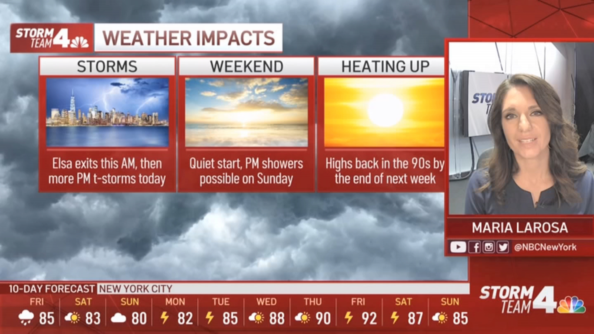
- A widespread 4 to 5 inches of rain fell across the region by the time Elsa moved out; more scattered thunderstorms are expected Friday after a brief relief from the storms
- Elsa killed at least one person in Florida and spawned a tornado that hurt others in Georgia
The last remnants of Tropical Storm Elsa roared into the tri-state area overnight, triggering a series of tornado warnings for parts of New Jersey and wreaking flash flood havoc in New York City with record rainfall into Friday morning.
Two confirmed tornados touched down in New Jersey as the storms slammed the tri-state. One occurred around 3:30 a.m. in Little Egg Harbor Township in Ocean County. That EF-0 tornado had wind speeds top out at 80 mph, as it snapped or uprooted several trees and led to damage for multiple houses along Rosemont Lane and Harbourtown Boulevard. The short-lived tornado traveled about a third of a mile in about a minute's time.
The other was an EF-1 tornado that touched down in Woodbine in Cape May County, which had wind speeds up to 100 mph.
Get Tri-state area news and weather forecasts to your inbox. Sign up for NBC New York newsletters.
By noon Friday, when the bulk of the tropical storm moved on, tens of thousands were left without power and flooding had closed too many roads to count.
The New York City area enjoyed a brief and pleasant respite from the rain Friday afternoon before another round of scattered thunderstorms started arriving in the evening. A severe thunderstorm warning was in effect for Atlantic, Burlington and Ocean counties in New Jersey until 9:30 p.m. as isolated storms passed through.
Between Elsa and severe storms that rolled through Thursday, parts of the tri-state got a month's worth of rain in just 24 hours.
Elsa delivered much of that record pace before moving out and up the east coast. Several cities reported rain totals that smashed the previous record by Friday at 9 a.m., with places like Central Park and Jersey City recording more than 4 inches in the past 24 hours.
Damaging winds tore down trees and caused destruction across parts of the tri-state area Thursday afternoon and into Friday. Overnight, a 78 mph gust was recorded in New Jersey's Ludlam Bay, while a 71 mph gust hit Beach Haven. Both appeared to be “associated with nearby tornadoes,” the National Hurricane Center said.
The system quickly moved over the mid-Atlantic states and into the northeastern United States and it is supposed to move out quickly as well. New York City experienced the heaviest rain until about 9 a.m.
By 11 a.m., only the eastern half of Long Island was still seeing precipitation, with the bulk of the storm heading for Boston and Cape Cod by noon.
Nassau and Suffolk counties, as well as Fairfield, were under flash flood warnings until noon, with all flood warnings expiring throughout the early afternoon. Instances of stranded cars in flood water have already been reported in Fairfield and Nassau counties.
Check the latest severe weather alerts for your neighborhood here.
Elected officials on both sides of the river had warned people to be prepared.
New York City has closed its mobile vaccination sites through Friday because of the forecast. It also issued a travel advisory for Friday, warning people to expect limited visibility and potentially difficult road and rail conditions throughout the day.
Multiple fallen trees suspended LIRR service on the Oyster Bay Branch around 9 a.m. Friday. An hour later, police in Nassau County reported several flooded roadways and a fallen tree blocking all southbound lanes of Meadowbrook State Parkway.
More From Storm Team 4

“New York City Emergency Management is in contact with the National Weather Service to prepare for the potential impacts from the heavy rain due to Tropical Storm Elsa,” NYC Emergency Management Commissioner John Scrivani said.
“The tropical storm has the potential to cause flooding, high winds, and damaged property as it moves over the city. New Yorkers must take time to prepare and take the appropriate precautions if they must move about the city during the storm,” he said.
A weakened but resilient Tropical Storm Elsa killed at least one person in Florida on Wednesday and injured several others when a possible tornado struck a campground at a Navy base in southeast Georgia.
Elsa is the earliest fifth-named storm on record, said Brian McNoldy, a hurricane researcher at the University of Miami.
The tri-state briefly dried out midday, but an approaching stirred up another round of scattered showers and thunderstorms for the tri-state area later Friday leading into the nighttime hours.
Before Elsa even arrived, several rounds of intense storms battered the area with blinding rain, damaging winds and even hail in some spots Thursday. Given how saturated the ground already is from the heavy downpours that battered the tri-state Thursday, flash flooding was not a surprise in many areas.
Any scattered storms that move through the area Friday night will quiet down overnight.
Saturday looks to be the best weekend day at this point because, for what feels like the first time in forever, there's no precipitation in the forecast (but to be fair, a stray shower can't be entirely ruled out). Partly sunny skies with a high of around 83 degrees can be expected. There is still a high risk for rip currents on the south shore of Long Island, and a moderate risk at the Jersey Shore.
Sunday looks less optimal, cloudy with a few showers in the afternoon, then storms are possibly come the evening. That kicks off a very stormy week, with thunderstorms possible almost every single day, except Thursday when temperatures will heat up to around 90.
Track the storms using our interactive radar below.
