
What to Know
- The humidity returned Wednesday, and it fueled thunderstorms in the tri-state area after a brief reprieve from summer showers
- Several counties were issued severe thunderstorm warnings as strong storms rolled through while the evening commute was about to begin
- The weather will temporarily clear up overnight, but expect the remnants of Dorian to bring showers, clouds and wind to the coast late week
The humidity returned Wednesday, and it fueled afternoon and evening thunderstorms in the tri-state area after a brief reprieve from summer showers.
A severe thunderstorm warning was issued for Ocean County in New Jersey until 10:15 p.m.
Earlier in the evening, several counties around the area — including most of New York City, northern New Jersey and parts of Long Island and Fairfield County — were issued severe thunderstorm warnings as strong storms rolled through while the evening commute was set to commence.
Videos on social media showed sheets of rain accompanied by hail falling in places from New Jersey to Brooklyn and out into Nassau County. Large tree limbs were reportedly knocked down in Gravesend.
Most of Tuesday stayed relatively dry, but storms started to fire up in Ulster County by early afternoon and were sliding east. Some of those storms looked became severe, dumping parts of the region with damaging winds, hail, torrential rain and an isolated tornado or two, Storm Team 4 says.
Many of the storm cells were fast-moving and went through the tri-state quickly. There were a few lingering islolated storms rolling through Pennsylvania that could hit parts of middle to southern New Jersey as the night wears on.
The National Weather Service issued a severe thunderstorm watch for virtually the entire tri-state region until 9 p.m., warning that nearly 35 million people could see high winds, hail and even the risk for a tornado or two.
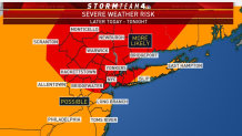
Parts of New York City, Pennsylvania, the Hudson Valley, northern New Jersey and Long Island are more likely to see dangerous winds and even some hail. All five boroughs of New York City are in the "more likely" zone for severe weather risk -- and the storms started firing up just ahead of the peak evening rush. (Scroll down for real-time commute updates from all your key transit sources.) Check the latest weather alert in your neighborhood here.
Local


Track the weather using our interactive radar below.
The storms should move out by midnight, and the skies look to be clear heading into the overnight hours, according to Storm Team 4.
Though conditions will clear up overnight, clouds, wind and showers from the remnants of Dorian will brush the coast by the end of the week, Storm Team 4 says. The severe weather threat follows a stormy Labor Day that saw thunderstorms sweep the region and a tornado touch down on Long Island. Track Dorian's path LIVE right here.
