The heavy, steady rain that besieged the tri-state area has cleared out, though showers are expected to linger through most of the day Wednesday, potentially adding more accumulation to the volume that fell over the last 48 hours -- and forecasters say we should brace for indirect impacts from Hurricane Earl over the weekend, too.
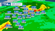
Nearly 6 inches of rain fell in parts of Connecticut's Fairfield County over the 48-hour period that ended Tuesday night, with Shelton recording 5.67 inches and Danbury seeing nearly 5 inches. Westchester County also saw significant accumulation, 5.39 inches in South Salem and 4.87 inches in Mount Kisco, while Staten Island was the only of the five boroughs to get more than 2 inches. Most of New Jersey saw less than the latter. Check rainfall totals in your county here.
All of those totals are likely to rise with the next National Weather Service update. Bridgeport, Connecticut, saw more than 2 inches fall after midnight and Putnam Lake saw another inch and a half. The rain had tapered off to scattered, light showers before dawn, but it is expected to stick around in some capacity, at least, through the better part of the day.
Get Tri-state area news and weather forecasts to your inbox. Sign up for NBC New York newsletters.
These conditions could improve severe drought conditions plaguing the tri-state area this summer, though it's unclear if the next U.S. Drought Monitor data release on Thursday will reflect a significant impact.
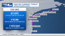
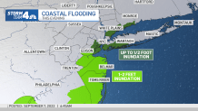
Minor coastal flooding is possible over the next few high tide cycles and the National Weather Service warns rip current risk will be high as well for the next few days. Check the latest weather alerts for your neighborhood here.
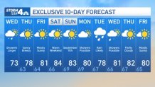
Sunshine returns Thursday and temperatures bounce back into the 80s for the rest of the week. The gorgeous forecast holds through the weekend, with showers not expected to return to the forecast until early next week.
10-Day Forecast
Tracking Hurricane Earl
Earl has intensified into a hurricane, the second of the Atlantic season, and is expected to become a category 3 storm before passing just east of Bermuda on Friday. There are already tropical storm watches in place. The tri-state won't see any direct impacts, but conditions may combine for indirect effects along the south shores of Long Island and New York City.
A few days of persistent east wind puts the tri-state area at a high risk for rip currents, and that is now likely to continue into the weekend as Earl generates big swells the next several days. The beach weather is still expected to be nice later this week, but the rip currents are important to stay aware of, given that many beaches lose lifeguards after Labor Day.
On a similar note, the easterly flow, a full moon late week, and building swells thanks to Earl could also cause some beach erosion and minor flooding during high tides, especially Friday and Saturday.
Track any approaching storms using our interactive radar below.