
This 2022-23 winter has proven unprecedented for the New York City area, taking a historic amount of time to bring even just four-tenths of an inch of accumulating snow to Central Park and recording above-average temperatures every single day of the same month for the first time ever, among other superlatives.
We notched another one Friday. The National Weather Service said its climate sites at Central Park and LaGuardia had already tied record daily highs for Feb. 10, with both locations reporting temps at 60 degrees or higher.
Why such a disappointing season for winter weather lovers, then? There are two main factors: Climate change and la niña.
Get Tri-state area news and weather forecasts to your inbox. Sign up for NBC New York newsletters.
The climate change impact is straightforward. Global temperatures are rising, and warmer weather means less snow. What’s interesting is that global warming doesn’t impact each season equally.
More Stories

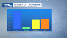
In the tri-state area, temperatures in winter are rising more quickly than they are in any other season, so climate change is more pronounced during the coldest months of the year. Overall, the 30-year average winter temperature has increased a full degree in the past decade, significantly more than in other seasons.
Obtenga más información en español aquí.
Secondly, the global wind pattern known as la niña is playing a part in keeping the snow away from the city, too. The term la niña is defined as colder-than-normal waters in the equatorial Pacific Ocean off the South American coast. And, while the Pacific Ocean is a long way away from here, it does impact us.
La niña leads to global upper-atmospheric wind patterns that promote generally warmer winters in the southern U.S. and along the East Coast. Locally, that upper-level wind, known as the jet stream, is most often positioned to the north of New York City. It’s the divide between warm air to the south from colder air to the north. It also serves as a path for storm systems to follow.

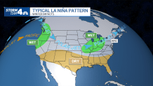
This winter, with the jet stream to our north, most storm systems have taken an inland track. That inland track usually concentrates precipitation in the Great Lakes region. In the New York City area, it usually always means rain when a storm system passes by.
For big snow to happen in the city, storm systems need to take an offshore track, which allows for sub-freezing air to dive down from Canada, intersect with moisture off the Atlantic Ocean, and produce loads of snow. That just hasn’t happened this year, and there’s no indication things will change in the next couple of weeks.
