
Want more snow? OK, but it won't be pretty, and it won't be much.
A clipper will bring a quick shot of rain-to-snow overnight. Whatever happens will only happen for about six hours or so, limiting impacts.
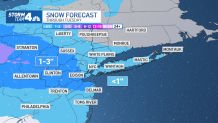
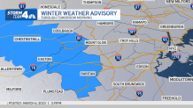
Most tri-state residents should just have to deal with wet roadways during their Tuesday morning commutes. Some may face at worst a slushy accumulation, as some heavier bands of snow could develop well west of NYC. There are a few winter weather advisories issued for counties of northwestern New Jersey, where up to 3 inches of slushy snow could accumulate.
Any snow that falls near the city will be much lower, certainly under an inch in total, and it will likely melt from the rain and above-freezing temperatures. Showers will wrap up by 5 a.m., then it will get gusty, with most of the day Tuesday feeling like the 20s and 30s.
Get Tri-state area news and weather forecasts to your inbox. Sign up for NBC New York newsletters.
Check the latest National Weather Service alerts here.
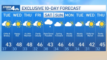
What's Next? 10-Day NYC Weather Forecast
Once the next system moves on, we're looking at a mainly quiet week with mostly sunny skies and temperatures in the mid-to-high 40s. There is a chance another storm could bring more rain and snow to the tri-state area this weekend, with accumulating flakes more likely in areas north and west of the city.
At this point, it doesn't appear the system will be much more than a wintry mess of sleet and freezing rain for most of us, but things could change, so stay with Storm Team 4 for all the latest need-to-know weather updates.
And for those wondering, we spring forward on March 12. Sign up for our newsletters here.
More News


Track any approaching precipitation using our interactive radar below.
