What to Know
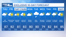
- Humidity will stick around for one more day Thursday, keeping it muggy while temperatures remain around normal, with highs in the mid to upper 80s
- There is a chance for scattered showers or isolated bouts of severe weather that lingers into Thursday morning before another front moves in at night, bringing drier air with it
- The weekend looks amazing, with low humidity and pleasantly warm summer highs starting Friday
The worst of the weather is behind us — just deal with one more day of humidity until a glorious weekend ahead.
Spotty showers and isolated thunderstorms are possible overnight into Thursday morning, but no widespread severe weather is expected. Spots south of New York City are more likely to see storm cells, but much could change.
The rain is expected to develop between 3-4 a.m., and could continue through sunrise. Coverage will be spotty, so while most places will stay dry, showers and some thunder are possible through 9 a.m., as the rain will push east toward Long Island. Check the latest weather alerts for your neighborhood here.
Get Tri-state area news and weather forecasts to your inbox. Sign up for NBC New York newsletters.
It will still be a warm and muggy Thursday, with highs in the mid to upper 80s. However, it will feel borderline refreshing compared to the insufferable heat and humidity endured from last week into earlier this week.
Come Thursday night, an approaching cold front will bring drier Canadian air and some early autumn-like weather going into the weekend. That means cool nights, warm sunny days and low humidity. Friday kicks off a week-plus-long stretch of below-average highs more reminiscent of early-to-mid-September weather than blazing August heat and humidity.
The threat of storms returns by Tuesday, which begins another unsettled pattern that keeps the tri-state area stormy through the end of next week. If it's any consolation, we need the rain -- and fear not, no awful heat is forecast for the next few weeks.
The rain that comes next week, with showers or thunderstorms possible from Tuesday to Friday, stands to be beneficial for many in the region, as drought conditions are especially widespread in New Jersey. Some of those areas may see as much as three inches of rain next week, which should improve the dry conditions.
The latest heat stretch saw more records fall, especially in New Jersey. Newark has recorded four heat waves, and now has had six 100-degree days since July 1, its hottest stretch of weather on record during this time frame. It also marks the third-most 100-degree days in a year at Newark Airport since 1931, when they began keeping records there.
Track any approaching weather using our interactive radar below.