What to Know
- It's looking like this winter will be a record-setter for NYC, with no measurable snowfall expected in Central Park through the rest of this month at least (the latest first date ever was Jan. 29)
- Much of the rest of the tri-state area, though, is feeling the wrath of winter Wednesday; the Catskills could see 8 inches or more of snow, while parts of the Hudson Valley and northern NJ may see anywhere from 1 to 5 inches before the system moves out
- Periods of heavy rain are likely later in the day and thunder is also possible in and around the city; Long Island and the Jersey Shore are expected to see all rain and coastal flooding is possible
Wintry weather is hitting the New York area, though measurable snow will likely stay out of the five boroughs, making this winter the latest-ever to see recorded snowfall in Central Park (if we get any at all).
It was snowing -- and raining -- in the city by early afternoon, but with temps near 40, don't expect it to stick.
Get Tri-state area news and weather forecasts to your inbox. Sign up for NBC New York newsletters.
Accumulating snowfall began late Wednesday morning north and west of New York City and spread over much of those spots throughout the afternoon. Most areas saw snow change to rain by late afternoon.
More snow was expected to persist in northwestern New Jersey, the Catskills and Hudson Valley into the early evening hours, but a dry pocket slipped into the area behind the snow, and could bring an end to much of the accumulation. Any snow later in the evening will likely turn over to rain, as temps will stay well above freezing.
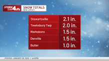
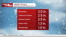
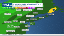
Parts of the Catskills were expecting to see more than 8 inches of snow, but will likely only get closer to three inches by the time the system moves out. Much of the Hudson Valley and New Jersey got 1-2 inches, before the snow turned over to rain.
It will likely make for a tricky evening commute, with steady rain for many and slushy snow to the north and west of the city.
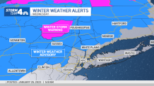
A winter storm warning remains in effect for New York's Ulster and Sullivan counties through 10 p.m. Wednesday. Find the latest severe weather alerts from the National Weather Service for your neighborhood here.
The city itself and areas along the coast saw a quick burst of snowfall during the early afternoon. But any snowfall that came rapidly changed over to rain shortly after, as temperatures continued to rise.
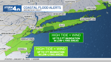
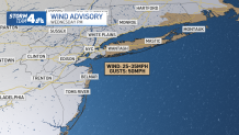
Expect virtually all rain for Long Island and central and southern New Jersey. A period of heavy rain, strong winds with gusts up to 50 mph and minor to locally moderate coastal flooding is likely Wednesday evening into the overnight hours. Thunder is also possible. The weather dries out by Thursday morning but winds stay gusty through afternoon.
Heavy Rain, Coastal Flooding Concerns and Winds
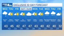
There is another chance for snow come the middle of next week, but at this point, it's too far off to determine with any confidence whether it will bring snow or just more rain. Stay with Storm Team 4 for all the latest updates.
Record-Setting NYC Winter?
We're a week away from the start of February, and for the first time all winter, we're able to we still can't say these words just yet: There is measurable snow in the forecast for New York City.
In a winter that has seen parts of the country walloped by historic snowstorms, including other areas of the Empire State, NYC has been notably bereft of the white stuff. Bereft might be too light a term, considering we haven't seen any measurable snow at all thus far -- and we're more than a month into the season already.
It looked like Wednesday might be marginally interesting for snow lovers, but now it's looking more interesting for Debbie Downers -- and those who love superlatives from the cynic's perspective. (Encuentra todos los detalles en español aquí mismo.)
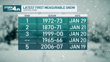
Should measurable snow actually come to Central Park Wednesday, it would mark the second-latest date ever in terms of first measurable snowfall recorded there. Should the snow yet again dodge the city and we make it until Monday without any of the white stuff — quite possible given the run of above-freezing highs — we've got a new record.
The latest date New York City has ever recorded accumulation is Jan. 29.
First Central Park Snow Averages
The latest-ever date is Jan. 29, a record set in 1973. So if we make it another 19 days with no measurable snow, at least we can find solace in the fact we'll tie or even break a record. It's too far out to accurately predict our chances beyond the 10-day right now, but we promise we'll keep you posted.
Yes, we've technically seen snowflakes this season, but trace amounts of snow mixed in with rain don't count for weather data recording purposes. (That's not us, that's the National Weather Service.)
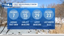
Last winter, Central Park recorded its first measurable snowfall on Dec. 23, although it was only 0.2 inches (so, you see, "trace" amounts are really nothing at all). The average first measurable snowfall in the city is Dec. 7, so we're already a month behind the average.
Looking ahead, it's not yet clear when the first major -- or even notable -- snowfall of this winter will hit NYC.
According to the Climate Prediction Center, it's possible we will see above-normal temperatures into February. The same models aren't quite definitive on what's in store in terms of precipitation.