
What to Know
- Light rain and snow showers arrive by Monday morning. It's just a taste of what's to come later in the storm
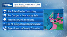
- Evening rain turns heavy and we'll start to see heavy snow north and west of the city piling up overnight
- Everyone in the city and along the coast will get soaked, but snow is still a possibility
We may be springing forward, but a "significant" winter system will blast much of the area this week, delivering a snow event likely to dump around a foot of snow for some in the tri-state.
The storm could start to roll in as early as late Sunday, but Monday is more likely. At this point, the usual cast of winter storm characters (snow, rain, wind) should make their grand entrance by late Monday and stick around through most of Tuesday.
Nothing is set in stone, however. The track on this storm has the potential to shift, which will be the ultimate decider on where and how much snow falls on the region.
Get Tri-state area news and weather forecasts to your inbox. Sign up for NBC New York newsletters.
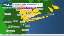
By the time the skies settle above the tri-state, it's possible some of us will be drenched from a few inches of good, heavy rainfall, while others could be digging out of a foot of snow.
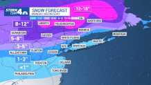
Temperatures appear to be the maker of this system, especially for New York City, Long Island and neighboring suburbs. The storm could be snow-less for this part of the tri-state if temps stay warm enough. If there is a colder shift, a couple inches of snow accumulation is still possible by the time the system clears out.
What does look fairly certain is the heavy snow projected for northern New Jersey and the Hudson Valley. The further north you look, the more snow you'll find by late Tuesday and early Wednesday. While a foot is possible for Sullivan, Dutchess and Ulster counties, those in Westchester, Fairfield and Rockland could still see around six inches.
No matter the totals, the Tuesday morning commute will be nasty regardless of where you're at. Do not be surprised to see a number of school cancellations.
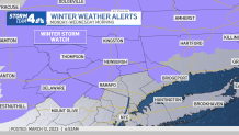
Winter storm watches have already been triggered for some north and west of the city. Stay with Storm Team 4 for all the latest need-to-know updates. Check the latest National Weather Service alerts here.
Storm Timeline and Expectations
NYC AND LONG ISLAND
- Monday: Periods of rain throughout the day
- Monday night: Heavy rain and possible localized flooding
- Tuesday: Rain mixes with and changes to snow; only minor accumulations
NORTHWEST NJ, CATSKILLS, LOWER HUDSON VALLEY AND CONNECTICUT
- Monday: Snow for Pike/Sullivan/north Orange counties early; may change to rain midday
- Monday night: Hours of heavy snow, possibly seeing half a foot by morning
- Tuesday: Snow continues for most of the day, getting lighter by afternoon
Winds will ratchet up as well, bringing gusts on Tuesday of 30 to 50 mph and maybe some stronger for Long Island. And while the storm pulls out Wednesday, the gusty winds should continue.
Temperatures tick back up the rest of the week with a mix of sunshine, clouds and a few showers for the St. Patrick's Day holiday weekend.
Sign up for our newsletters here.
More News


Track any approaching precipitation using our interactive radar below.
