
What to Know
- Storm Team 4 expects above-average temperatures and below-average snow this winter.
- Climate change has become one of the key factors in determining how winter will pan out.
- Storms could drop heavy rain and snow when they hit.
Don’t put away your shorts and t-shirts just yet: Storm Team 4 is calling for another mild winter for the tri-state.
Coming off one of the warmest winters on record for Central Park, meteorologist Janice Huff says this coming winter could be similar.
Temperatures are expected to be above-average through February, but that doesn’t mean winter is canceled.
“It will still get cold and we still feel winter’s chill, but those arctic blasts won’t last as long,” said Huff. “And, we’re looking at more extremes – higher highs and lower lows.”
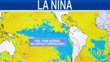
Climate change has become a key factor in this year’s winter outlook.
“For the first time ever, Storm Team 4 considered the effects of climate change on our winter outlook,” said Huff.
News
Global temperatures are at historical highs and the amount of Arctic sea ice has plummeted to record lows.
And while there are dozens of factors that go into long-range forecasting, scientists point to climate change as the x-factor.

Huff stressed, “We’ve never been here before in our lifetime, and there is a lot of uncertainty going forward.”
Last winter, Central Park only recorded 4.8” of snow – fourth least snowy on record.
Storm Team 4 is calling for below normal snowfall again this winter but expects more than last season.
“A typical Central Park winter means about 26” of snow. We’re expecting less than that again this winter,” Huff said.
But, when the big storms hit, Storm Team 4 warns they could bring heavier rain and heavier snow.
With more water vapor in the atmosphere than ever before, storm systems are dropping heavier amounts of precipitation.
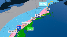
And, with warmer air in place, the rain-snow line is expected to hug the Interstate 95 corridor of the Northeast. This means more mixed-phase events for the tri-state: rain, sleet, and snow all-in-one.
Huff says our understanding of the atmosphere has come a long way during her career.
Innovative satellite technology, advanced computer modeling, and StormTracker 4—the tri-state’s most powerful radar—have helped make Storm Team 4’s predictions the best in the tri-state.
WeatheRate, an independent weather forecast verification company, certifies that Storm Team 4 has the most accurate forecast in the tri-state area.
“We’re predicting the weather better than ever, but we’re still working to identify how climate change is affecting our everyday weather,” said Huff.
Whatever comes our way this winter, Storm Team 4 will be here to keep you and your family prepared for winter’s worst.
