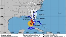
Hurricane Ian once again gained strength on Tuesday, emerging over the southeastern Gulf of Mexico as a category 3 storm after leaving Cuba completely in the dark before setting its sights on Florida, where it is expected to approach the western coast as an "extremely dangerous major hurricane," according to the National Hurricane Center.
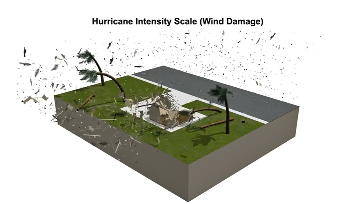
Maximum sustained wind speeds stayed consistent at 120 mph in NHC's 2 a.m. update, but Ian is expected to grow stronger Wednesday until it makes landfall, which should happen during the day. It's about 95 miles southwest of Naples and slowly churning north-northeast, NHC says. Learn about hurricane categories and max wind speeds here. Ian may be a category 4 storm by the time it makes landfall.
Tropical storm warnings and watches are now in effect for parts of Georgia and South Carolina, where Ian is expected to move after hitting the Fort Myers area and moving through central Florida by Thursday. Tornadoes are possible through Wednesday across the Keys and southern and central peninsula, and life-threatening storm surges are expected along with catastrophic winds and flooding.
Tornado Watch for South Florida
Get Tri-state area news and weather forecasts to your inbox. Sign up for NBC New York newsletters.
Mandatory evacuation orders are in effect for more than two million people, with multiple major airports already closed, and bridges set to be shut down as the storm gets closer. See a county-by-county breakdown. Tropical storm warnings for the U.S. East Coast have been extended as well.
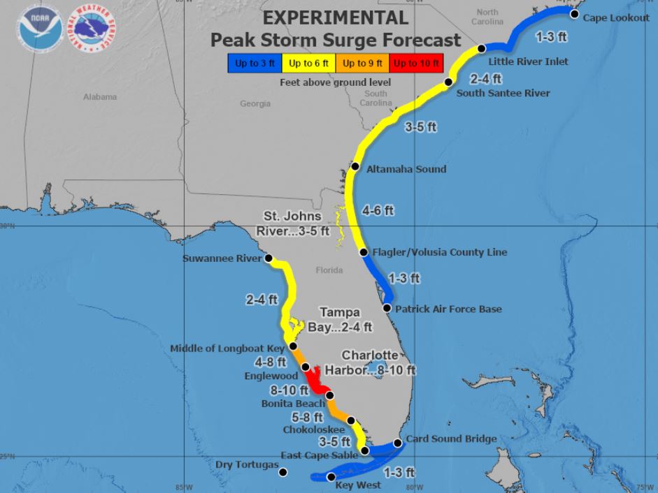
A storm surge warning, meaning deadly inundation could hit within 48 hours, has been extended for the eastern coast of Florida, from Marineland to the mouth of St. Mary's River, including St. Johns River. On the Gulf Coast side of the state, a warning has been issued from Suwanee River down to Flamingo, and covers the Tampa Bay area as well as Dry Tortugas.
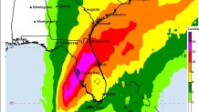
Peak Storm Surge Forecast
A hurricane warning has been extended south along the west coast of Florida from just north of Tampa down to Chokoloskee, while a tropical storm warning is in effect for the Florida Keys and nearly the entirety of the coastline for the rest of the state, save for further reaches of the panhandle.
A surge of up to 6 feet of ocean water and 18 inches of rain is predicted across the Tampa Bay area, with as much as 24 inches in isolated areas. Areas from the middle of Longboat Key to Bonita Beach, including Charlotte Harbor, could see a 12-foot storm surge. That's more than enough water to inundate low-lying coastal communities. Widespread flash and urban flooding are expected mid-to-late week across central and northern Florida, as well as some southern areas.
Hurricane conditions can be expected along Florida's west coast by Wednesday morning, with tropical storm conditions just before that. Those conditions spread up to Georgia and South Carolina on Thursday.
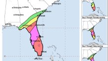
Rainfall Potential
Flash Flood Risk
The deepest water will occur along the immediate coast, near and to the right of the center, where the surge will be accompanied by large waves, NHC says. Surge-related flooding depends on the relative timing of the surge and the tidal cycle and can vary greatly over short distances, so people are advised to check their local weather offices for details.
On the current track, the center of Ian is expected to pass west of the Florida Keys overnight into Wednesday, and approach the west coast of Florida within the hurricane warning area on Wednesday. Hurricane-force winds extend outward up to 40 miles from Ian's center, and tropical-storm-force winds extend outward about 140 miles, NHC says.
The recent shift in track for Ian is slight, but it's enough to have a big impact on how the Florida Gulf Coast will experience the storm as it comes ashore. Fort Myers is now expected to get the worst of the storm, as Ian is anticipated to make landfall just north of the coastal city as a Category 3 or 4 storm on Wednesday. The west coast of Florida will feel some of the worst impacts by the afternoon hours ahead of that.
Wind and storm surge will be greatest near Ft. Myers. Flash flooding, which becomes a bigger issue as Ian weakens and crawls across the state on Thursday, will be most catastrophic from Tampa up the I-4 corridor to Daytona Beach.
The system is expected to largely stall over the western coast of Florida, which compounds the potential impacts. The Category 3 storm is expected to strengthen further late Tuesday through Wednesday.
Widespread catastrophic flash, urban, and river flooding is expected across central Florida, while southern portions of the state could see similar conditions. Those flooding concerns stretch up to northwest Florida, Georgia and coastal South Carolina later in the week and through the weekend.
“Please treat this storm seriously. It’s the real deal. This is not a drill,” Hillsborough County Emergency Management Director Timothy Dudley said at a Monday news conference on storm preparations in Tampa.
Florida residents were getting ready, lining up for hours in Tampa to collect bags of sand and clearing store shelves of bottled water. As many as 300,000 people may be evacuated from low-lying areas in Hillsborough County alone, county administrator Bonnie Wise said at a news conference Monday on preparations.
As Florida braces and prepares, the storm left the entire island of Cuba without power, according to the island's electricity provider. The power authorities said that electricity will be restored gradually overnight into early Wednesday morning.
Florida Gov. Ron DeSantis expanded the declaration of a state of emergency Saturday to include the entire state. While many residents (particularly those with ties to the northeast) looked to get on some of the last flights north, the governor said getting that far away isn't necessary.
"You do not need to evacuate to another state, you don't need to go hundreds of miles away. There are shelters that are open in all of these counties at this point," DeSantis said.
The governor and President Joe Biden are said to be in "close coordination" in regard to the storm and possible federal assistance that could be needed afterward.
"Your safety is more important than anything. And I know our hearts are with everyone who will feel the effects of this storm," Biden said.
By Thursday, Ian is expected to slow down and weaken along the Florida coast, making wind less of an issue — though rain will still be a primary, and potentially life-threatening, concern. Flash floods are likely in Florida as the storm continues its slow trek north, and parts of the Carolinas and Georgia could see similar threats later in the week.
Ian is expected to hit those areas as a tropical depression Thursday and Friday and trigger heavy rainfall in the southeastern U.S. Friday and Saturday before potentially barely clipping the tri-state area on Sunday. No significant local impacts are expected. South Jersey appears most likely to see heavy rain at this point, though flash flood risk is minimal.
The latest weather threat comes a week after Hurricane Fiona devastated Puerto Rico and the Dominican Republic.
Communities in southern parts of Puerto Rico were inundated with torrential rain and wild winds, amounting to more than 2 feet of water in spots as the threat of deadly mudslides loomed. Lago Cerillos, not far from Ponce, where Fiona made landfall in Puerto Rico ahead of a second landfall in the Dominican Republic a day later, saw nearly 3 feet of rain.
President Joe Biden declared a state of emergency for Puerto Rico ahead of the storm, while the governor of Puerto Rico, as the worst of it hit, described "catastrophic" damages as the island plunged into darkness.