
What to Know
- Record-high daily temperatures warmed much of the tri-state area Wednesday as the mercury climbed to the high 60s in spots; it won't last, though, with winter returning with a vengeance on Thursday.
- By Thursday night, a storm that develops across the south-central United States moves our way — bringing with it the threat of snow and ice or a wintry combination to many in the tri-state
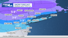
- Parts of northern NJ along with interior parts of the Hudson Valley and CT's Fairfield County could see up to 5 inches of snow by Friday morning; NYC, Long Island and other coastal areas expect 1-3 inches
Drastic changes in temperature and a wintry mix threatening everything from accumulating snow to sleet, freezing rain and rain are all on the table in the end-of-week forecast -- and Friday could turn into a downright sloppy mess for many.
Temperatures climbed to the high 60s across parts of the tri-state area on Wednesday, breaking daily records at all of the local airports. But then it was a quick and rude return back to winter, with temperatures plunging by evening.
Thursday started out below freezing, with daytime temperatures peaking in the mid-30s, at best.
Get Tri-state area news and weather forecasts to your inbox. Sign up for NBC New York newsletters.
By Thursday night, a storm that develops across the south-central United States moves our way — bringing with it the threat of snow and ice, or a wintry combination, to many in the tri-state.
The bulk of the precipitation will come after 11 p.m. Thursday night, and spots north of I-84 could see snowfall rates of up to 2 inches an hour at times.
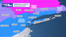
Winter storm warnings are up for Sullivan, Dutchess and Ulster counties, and winter weather advisories are in place for much of the rest of the region, including New York City, northeast New Jersey, and Westchester and Fairfield counties.
Those far reaches of New Jersey, along with interior parts of the Hudson Valley and Fairfield County, are expected to see 3 to 5 inches of snow by Friday morning. Those areas will get snow to start, before it changes over to an icy mix.
News


Areas north of there are likely to see even more snow, up to 8 inches for some in the far northern counties of our region.
Much of New York City is expected to only get around an inch or so of snow from the storm, with the same going for Long Island and parts of central and coastal New Jersey. Some spots in northeastern New Jersey and along the coast of Westchester County and up into coastal Connecticut could see slightly more precipitation, but only up to 3 inches.
Those areas are more likely to see a few hours of a wintry mix of snow, sleet and freezing rain -- enough to make for a very messy Friday morning commute for tens of thousands of people across the region. It will turn to rain by mid-morning.
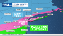
After possibly seeing a few snow showers Thursday afternoon, places in central New Jersey and along the Jersey Shore may not see much in terms of any accumulation at all, as it will be mostly rain. But given the timing of the precipitation, it could still be a messy start to Friday.
Check the latest weather alerts here.
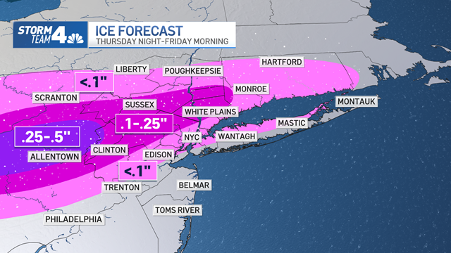
Ice is also expected to be a factor with this storm system. The entire New York City area and surrounding areas could see more than a hundredth of an inch of ice accumulate through Friday, which could weigh down power lines and slicken roads. Bridges and overpasses could remain icy all day Friday.
Areas to the north and west of the city could see even more ice buildup, up to a quarter of an inch for much of northwestern New Jersey and into the Hudson Valley. As much as half an inch is possible just over the western New Jersey border into Pennsylvania, near Allentown.
The weather pattern turns quieter after Friday's muck, though it will stay cold. Saturday is expected to see temperatures hover around the freezing mark, though Sunday looks to rebound into the low 40s. At this point, it looks like another frigid start to next week, with high temperatures forecast below freezing on Monday.
Expect temperatures to range from the high 30s to high 40s through the rest of next week under sunny or partly sunny skies.
Check any approaching precipitation using our interactive radar below.
