
What to Know
- Snow walloped parts of the tri-state Monday; areas south and east of NYC saw the highest snowfall totals
- The governor of New Jersey issued a state of emergency for coastal counties expected to face the brunt of the winter storm; NYC issued a winter operations advisory for potentially ice roadways
- NYC could have seen up to a couple inches but few New Yorkers saw any flakes during the day on Monday
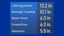
The first major winter storm event of the year delivered a whopping 13 inches of snow in some parts of New Jersey where its governor declared a statement of emergency, and it won't be the only chance of snow this week.
After a day of significant accumulation along the coast, the snow that first started following in the early morning hours has mostly concluded its strike on the Garden State and parts of Long Island. And while New York City implemented a travel advisory ahead of the storm's arrival, the winter wonderful skipped the city and stayed south and east.
Snow totals were highest in Ocean County and further south in the state, where flakes fell at a rate of 1 to 2 inches an hour at times. Winter storm warnings for the impacted counties expired by Monday evening, but the state of emergency remains until Tuesday morning.
Get Tri-state area news and weather forecasts to your inbox. Sign up for NBC New York newsletters.
Check the latest weather alerts for your neighborhood here.

(Click here for the snow report in your town.)
Weather Stories

The concern for commuters now shifts toward the wet roads that would turn to sheets of ice. Gov. Phil Murphy described the storm as the "most significant South Jersey snow event in almost exactly four years."
On certain parts of the Jersey Shore, like in Stone Habor, the snow combined with coastal flooding created floating ice sheets along the streets. A number of drivers spun out on the snow-covered roads and many were stranded across lanes that looked like they were engulfed in a blizzard.
New Jersey State Police said officers responded to approximately 200 calls for accidents during and after the storm.
Although the snow threat is in the rearview, especially for those not in the storm's direct path, temperatures remain frigid for the entire region. The overnight low in Central Park could reach 10 degrees below freezing, Storm Team 4 warns.
The first significant snowfall of the new year may feel like whiplash for many who experienced a warmer than usual Sunday. By mid-day, temperatures had already tied or broken records at JFK and LaGuardia airports.
Tuesday will be less cold than Monday and while it's still chilly in the high 20s to low 30s, we'll also get some sunshine. Scattered showers are expected to return by Wednesday before we get another break on Thursday.
However, Storm Team 4 warns of another chance for flakes come Friday, though a lot of accumulation isn't likely at this point.
