
Snow in January? Groundbreaking.
Only this year, it really would be. That's because we haven't had any measurable snowfall in New York City at all thus far in the season, which is about a month old by now.
It's even more surprising given that other parts of the country have been simply walloped by historic storms, including other areas of the Empire State, like Buffalo. But for those in the tri-state area, it's been a very different story devoid of the white stuff.
Get Tri-state area news and weather forecasts to your inbox. Sign up for NBC New York newsletters.
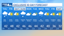
So the question remains: When will we get snow? For the vast majority of us, not this week -- but there's a chance later next week, according to the extended forecast.
There will be plenty of precipitation between now and that slight possibility next Thursday. Only problem: That precipitation comes when temperatures will be about 10-15 degrees too warm.
Rain comes back to the area Thursday, with chilly, breezy and wet conditions for much of the day. Rain is expected most of the day and could be heavy at times, so bring an umbrella, while temperatures will struggle to get past the low 40s.
News


With temperatures closer to freezing far north and west of the city — in Dutchess, Sullivan and Ulster counties — there could be a period of mixing rain and snow through the day Thursday. There is a Winter Weather Advisory in effect for some of those higher elevations for snow and ice. Roads may become slippery, possibly making driving treacherous.
Friday and Saturday look clear and a touch warmer, giving us a short break. Rain is threatening to put a damper on any end-of-weekend plans, with split impacts possible — rain in and around the city, with possibility for accumulating snow further north. Those showers will likely carry over into early Monday morning.
The parade of storms continues with another on the horizon come Wednesday, when showers are possible, and Thursday. While there is a chance for some snow, that system appears like it will mostly be a rain event, especially closer to the city, with much colder air to follow.
It's still too early to tell what will come of next week's weather, so stick with Storm Team 4 for the latest updates.
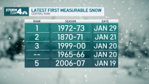
When was the last time it took this long to see measurable snowfall in the five boroughs? Well, the latest date New York City has ever recorded accumulation is Jan. 29. That means if no snow were to come from that Wednesday/Thursday system (the 25th and 26th), we would likely see a new record set.
If no snow falls this coming weekend (which is very much looking like the case), it will be the second-longest time before first measurable snow fell in NYC. The Jan. 29 record was set in 1973.
Record-Setting NYC Winter?
First Central Park Snow Averages
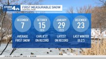
Yes, we've technically seen snowflakes this season, but trace amounts of snow mixed in with rain don't count for weather data recording purposes. (That's not us, that's the National Weather Service.)
Last winter, Central Park recorded its first measurable snowfall on Dec. 23, although it was only 0.2 inches (so, you see, "trace" amounts are really nothing at all). The average first measurable snowfall in the city is Dec. 7, so we're already a month behind the average.
Looking ahead, it's not yet clear when the first major -- or even notable -- snowfall of this winter will hit NYC.
According to the Climate Prediction Center, it's possible we will see above-normal temperatures through the rest of the month. The same models aren't quite definitive on what's in store in terms of precipitation.
