
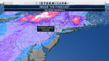
What to Know
- 6 inches of snow caused an epic commute nightmare for NYC, with some frustrated travelers calling for Mayor de Blasio to step down
- NJ didn't fare much better; people were seen trying to push an NJ Transit bus through snow as others just abandoned vehicles on roads
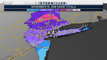
- Connecticut saw more snow than most of NJ and the city, with New Fairfield reporting 10.9 inches of the white stuff
How could 6 inches of snow turn into such a disaster for a city accustomed to handling feet? What happened with the forecast? Why was it all such a mess? We can't answer all those questions, but Storm Team 4 offers a bit of a forecast post-mortem on the storm that will henceforth be known as #Snowvember.
THE SETUP
High pressure centered in northern New England brought us a sunny and cold start to the day Thursday. Temperatures were below freezing throughout most of the tri-state area, and the air was bone-dry, setting the stage for accumulating snow. At the same time, a coastal storm was making its way northward.
THE FORECAST
On Wednesday night, Storm Team 4 predicted that snow would move into the tri-state area, changing to a wintry mix in the afternoon before changing to rain in the evening. That initial forecast called for 1 to 3 inches of snow and sleet in the city and close-in suburbs. By Thursday morning, the forecast totals were increased. The new forecast for the city called for 3 to 5 inches. An evening transition to rain was still in the forecast.
[PHOTOS] Storm Downs Trees Across NYC, Tri-State
THE REALITY
As predicted, snow began to fall in the city shortly after noon. The intensity picked up very quickly, and importantly, a wintry mix did not develop in the afternoon. The mixing factor, with sleet and freezing rain, would have kept snow totals on the lower side. It wasn’t until 8 p.m. that Central Park began reporting a wintry mix, and at 9 p.m., light rain was falling atop several inches of snow.
THE WHY
Local


The precipitation remained as snow for a longer period of time than expected. This is probably due to evaporational cooling. The bone-dry airmass on Thursday morning had a tremendous capacity to steal moisture from the falling snow.
When moisture evaporates, it cools the air surrounding it. This cooling process likely caused the snow portion of our winter weather event to last a few hours longer than expected. By the time rain took over, there was plenty of snow on the ground, and that prevented quick melting. Also, the rain fell very lightly in the city through the evening hours. It was not heavy enough to penetrate the snowpack, which again prevented further melting. Instead, many of us in the tri-state ended up with compacted snow and ice covering streets and sidewalks.
